Miłkowice geodata
Miłkowice (Lower Silesia) is a populated place; located in Poland in Europe/Warsaw (GMT+2) time zone. With population of 2,000 people, there are 1469 cities with bigger population in this country. Compared to other cities in Poland, 52.2% of cities are located further ↓South; 92.1% of cities are located further →East and 68.2% of cities have higher elevation than Miłkowice. Note1


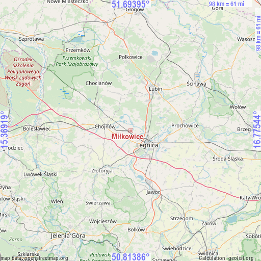
Miłkowice GPS coordinates[2]
51° 15' 21.636" North, 16° 4' 20.316" East
| Map corner | latitude | longitude |
|---|---|---|
| Upper-left | 51.69395°, | 15.36919° |
| Center: | 51.25601°, | 16.07231° |
| Lower-right: | 50.81386°, | 16.77544° |
| Map W x H: | 97.9×97.9 km | = 60.8×60.8mi |
| max Lat: | 54.83135° ⇑47.8% North |
| Miłkowice: | 51.25601° |
| min Lat: | ⇓52.2% South 49.21328° |
| min Long | Miłkowice | max Long |
| 14.20249° | 16.07231° | 24.03723° |
| W 7.9%⇐ | ⇒92.1% E |
Elevation
Elevation of Miłkowice is 125 m = 410 ft, and this is 66.4 m = 218 ft below average elevation for this country.
| Max E: |
974 m = 3196 ft | 68.2% |
| Avg. | 191.4 m = 628 ft | |
| Miłkowice | 125 m = 410 ft | |
Min E: |
-3 m = -10 ft | 31.8% |
See also: Poland elevation on elevation.city.
Geographical zone
Miłkowice is located in North temperate zone (between Tropic of Cancer and the Arctic Circle). Distance of this North polar circle is 1702 km =1057.6 mi to North.| Distance of | km | miles | from Miłkowice |
|---|---|---|---|
| North Pole | 4307.9 | 2676.8 | to North |
| Arctic Circle | 1702 | 1057.6 | to North |
| Tropic Cancer | 3093.2 | 1922 | to South |
| Equator | 5699.1 | 3541.3 | to South |


Nearby cities:
15 places around Miłkowice: (largest is in red/bold)
• Chojnów
9.6 km =6 mi,  281°
281°
• Krotoszyce
12.3 km =7.6 mi,  188°
188°
• Krzywa
18.4 km =11.4 mi, 279°
• Kunice
12.8 km =8 mi,  107°
107°
• Legnica
8.1 km =5 mi,  129°
129°
• Legnickie Pole
17.2 km =10.7 mi,  136°
136°
• Lisowice
19.5 km =12.1 mi,  79°
79°
• Lubin
18.4 km =11.4 mi,  29°
29°
• Męcinka
20.4 km =12.7 mi,  175°
175°
• Olszanica
19.7 km =12.2 mi,  253°
253°
• Osiek
16.7 km =10.4 mi,  42°
42°
• Prochowice
20.5 km =12.7 mi, 84°
• Wilków
20.8 km =12.9 mi,  208°
208°
• Zagrodno
16.1 km =10 mi,  243°
243°
• Złotoryja
17.9 km =11.1 mi,  216°
216°
Sources, notices
• [Note1] Compared only with cities in Poland existing in our database
• [Src1] Map data: © OpenStreetMap contributors (CC-BY-SA)
• [Src2] Other city data from geonames.org with taken over terms of usage.
• [Src3] Geographical zone / Annual Mean Temperature by Robert A. Rohde @ Wikipedia
