Legnica geodata
Legnica (Lower Silesia) is a seat of a third-order administrative division; located in Poland in Europe/Warsaw (GMT+2) time zone. With population of 106,033 people, there are 45 cities with bigger population in this country. Compared to other cities in Poland, 51.1% of cities are located further ↓South; 91.7% of cities are located further →East and 69.8% of cities have higher elevation than Legnica. Note1


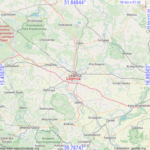
Legnica GPS coordinates[2]
51° 12' 36.216" North, 16° 9' 42.84" East
| Map corner | latitude | longitude |
|---|---|---|
| Upper-left | 51.64844°, | 15.45878° |
| Center: | 51.21006°, | 16.1619° |
| Lower-right: | 50.76747°, | 16.86503° |
| Map W x H: | 98×98 km | = 60.9×60.9mi |
| max Lat: | 54.83135° ⇑48.9% North |
| Legnica: | 51.21006° |
| min Lat: | ⇓51.1% South 49.21328° |
| min Long | Legnica | max Long |
| 14.20249° | 16.1619° | 24.03723° |
| W 8.3%⇐ | ⇒91.7% E |
Elevation
Elevation of Legnica is 121 m = 397 ft, and this is 70.4 m = 231 ft below average elevation for this country.
| Max E: |
974 m = 3196 ft | 69.8% |
| Avg. | 191.4 m = 628 ft | |
| Legnica | 121 m = 397 ft | |
Min E: |
-3 m = -10 ft | 30.2% |
See also: Legnica elevation on elevation.city.
Geographical zone
Legnica is located in North temperate zone (between Tropic of Cancer and the Arctic Circle). Distance of this North polar circle is 1707.1 km =1060.7 mi to North.| Distance of | km | miles | from Legnica |
|---|---|---|---|
| North Pole | 4313 | 2680 | to North |
| Arctic Circle | 1707.1 | 1060.7 | to North |
| Tropic Cancer | 3088.1 | 1918.9 | to South |
| Equator | 5694 | 3538.1 | to South |


Nearby cities:
15 places around Legnica: (largest is in red/bold)
• Chojnów
17.2 km =10.7 mi,  294°
294°
• Jawor
17.8 km =11.1 mi,  172°
172°
• Krotoszyce
10.7 km =6.6 mi,  229°
229°
• Kunice
6.2 km =3.9 mi,  77°
77°
• Legnickie Pole
9.2 km =5.7 mi,  142°
142°
• Lisowice
15.6 km =9.7 mi,  55°
55°
• Mierczyce
16.8 km =10.4 mi, 140°
• Miłkowice
8.1 km =5 mi,  309°
309°
• Męcinka
15.8 km =9.8 mi,  196°
196°
• Osiek
18.2 km =11.3 mi,  15°
15°
• Prochowice
15.8 km =9.8 mi, 63°
• Wilków
20.9 km =13 mi, 231°
• Wądroże Wielkie
15.8 km =9.8 mi,  131°
131°
• Zagrodno
20.8 km =12.9 mi,  264°
264°
• Złotoryja
19.3 km =12 mi,  241°
241°
Sources, notices
• [Note1] Compared only with cities in Poland existing in our database
• [Src1] Map data: © OpenStreetMap contributors (CC-BY-SA)
• [Src2] Other city data from geonames.org with taken over terms of usage.
• [Src3] Geographical zone / Annual Mean Temperature by Robert A. Rohde @ Wikipedia
