Lubień Kujawski geodata
Lubień Kujawski (Kujawsko-Pomorskie) is a seat of a third-order administrative division; located in Poland in Europe/Warsaw (GMT+2) time zone. With population of 1,293 people, there are 2098 cities with bigger population in this country. Compared to other cities in Poland, 74.8% of cities are located further ↓South; 56.8% of cities are located further →East and 67.8% of cities have higher elevation than Lubień Kujawski. Note1
Administrative division(s):
- Level 1: Kujawsko-Pomorskie
- Level 2: Powiat włocławski
- Level 3: Lubień Kujawski


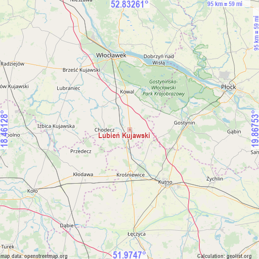
Lubień Kujawski GPS coordinates[2]
52° 24' 20.664" North, 19° 9' 51.84" East
| Map corner | latitude | longitude |
|---|---|---|
| Upper-left | 52.83261°, | 18.46128° |
| Center: | 52.40574°, | 19.1644° |
| Lower-right: | 51.9747°, | 19.86753° |
| Map W x H: | 95.4×95.4 km | = 59.3×59.3mi |
| max Lat: | 54.83135° ⇑25.2% North |
| Lubień Kujawski: | 52.40574° |
| min Lat: | ⇓74.8% South 49.21328° |
| min Long | Lubień Kujawsk | max Long |
| 14.20249° | 19.1644° | 24.03723° |
| W 43.2%⇐ | ⇒56.8% E |
Elevation
Elevation of Lubień Kujawski is 126 m = 413 ft, and this is 65.4 m = 215 ft below average elevation for this country.
| Max E: |
974 m = 3196 ft | 67.8% |
| Avg. | 191.4 m = 628 ft | |
| Lubień Kujawski | 126 m = 413 ft | |
Min E: |
-3 m = -10 ft | 32.2% |
See also: Poland elevation on elevation.city.
Geographical zone
Lubień Kujawski is located in North temperate zone (between Tropic of Cancer and the Arctic Circle). Distance of this North polar circle is 1574.2 km =978.2 mi to North.| Distance of | km | miles | from Lubień Kujawski |
|---|---|---|---|
| North Pole | 4180.1 | 2597.4 | to North |
| Arctic Circle | 1574.2 | 978.2 | to North |
| Tropic Cancer | 3221.1 | 2001.5 | to South |
| Equator | 5827 | 3620.7 | to South |


Nearby cities:
15 places around Lubień Kujawski: (largest is in red/bold)
• Baruchowo
12 km =7.5 mi,  34°
34°
• Boniewo
19.7 km =12.2 mi,  289°
289°
• Choceń
13.6 km =8.5 mi,  311°
311°
• Chodecz
9.3 km =5.8 mi,  269°
269°
• Chodów
20.2 km =12.6 mi,  210°
210°
• Czerniewice
12.9 km =8 mi,  335°
335°
• Dąbrowice
11.8 km =7.3 mi, 207°
• Kaliska
3.1 km =1.9 mi, 274°
• Kowal
13.9 km =8.6 mi,  355°
355°
• Krośniewice
16.7 km =10.4 mi,  178°
178°
• Nowe Ostrowy
11.6 km =7.2 mi,  170°
170°
• Ostrowy
11.3 km =7 mi, 179°
• Przedecz
19.7 km =12.2 mi,  246°
246°
• Strzelce
19.3 km =12 mi,  121°
121°
• Łanięta
9.2 km =5.7 mi, 121°
Sources, notices
• [Note1] Compared only with cities in Poland existing in our database
• [Src1] Map data: © OpenStreetMap contributors (CC-BY-SA)
• [Src2] Other city data from geonames.org with taken over terms of usage.
• [Src3] Geographical zone / Annual Mean Temperature by Robert A. Rohde @ Wikipedia
