Baruchowo geodata
Baruchowo (Kujawsko-Pomorskie) is a seat of a third-order administrative division; located in Poland in Europe/Warsaw (GMT+2) time zone. With population of 434 people, there are 3576 cities with bigger population in this country. Compared to other cities in Poland, 76.3% of cities are located further ↓South; 54.9% of cities are located further →East and 90.2% of cities have higher elevation than Baruchowo. Note1
Administrative division(s):
- Level 1: Kujawsko-Pomorskie
- Level 2: Powiat włocławski
- Level 3: Baruchowo


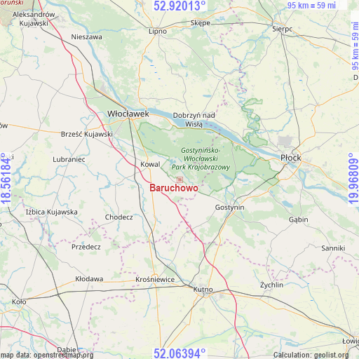
Baruchowo GPS coordinates[2]
52° 29' 38.832" North, 19° 15' 53.856" East
| Map corner | latitude | longitude |
|---|---|---|
| Upper-left | 52.92013°, | 18.56184° |
| Center: | 52.49412°, | 19.26496° |
| Lower-right: | 52.06394°, | 19.96809° |
| Map W x H: | 95.2×95.2 km | = 59.2×59.2mi |
| max Lat: | 54.83135° ⇑23.7% North |
| Baruchowo: | 52.49412° |
| min Lat: | ⇓76.3% South 49.21328° |
| min Long | Baruchowo | max Long |
| 14.20249° | 19.26496° | 24.03723° |
| W 45.1%⇐ | ⇒54.9% E |
Elevation
Elevation of Baruchowo is 75 m = 246 ft, and this is 116.4 m = 382 ft below average elevation for this country.
| Max E: |
974 m = 3196 ft | 90.2% |
| Avg. | 191.4 m = 628 ft | |
| Baruchowo | 75 m = 246 ft | |
Min E: |
-3 m = -10 ft | 9.8% |
See also: Poland elevation on elevation.city.
Geographical zone
Baruchowo is located in North temperate zone (between Tropic of Cancer and the Arctic Circle). Distance of this North polar circle is 1564.4 km =972.1 mi to North.| Distance of | km | miles | from Baruchowo |
|---|---|---|---|
| North Pole | 4170.3 | 2591.3 | to North |
| Arctic Circle | 1564.4 | 972.1 | to North |
| Tropic Cancer | 3230.9 | 2007.6 | to South |
| Equator | 5836.8 | 3626.8 | to South |


Nearby cities:
15 places around Baruchowo: (largest is in red/bold)
• Choceń
17.1 km =10.6 mi,  267°
267°
• Chodecz
18.9 km =11.7 mi,  238°
238°
• Czerniewice
12.2 km =7.6 mi,  279°
279°
• Dobrzyń nad Wisłą
16.4 km =10.2 mi,  12°
12°
• Gostynin
15.2 km =9.4 mi,  118°
118°
• Kaliska
13.7 km =8.5 mi,  225°
225°
• Kowal
8.9 km =5.5 mi,  296°
296°
• Lubień Kujawski
12 km =7.5 mi,  214°
214°
• Nowe Ostrowy
21.8 km =13.5 mi,  193°
193°
• Nowy Duninów
17.6 km =10.9 mi,  55°
55°
• Ostrowy
22.1 km =13.7 mi,  197°
197°
• Strzelce
22.1 km =13.7 mi,  154°
154°
• Włocławek
21.7 km =13.5 mi,  322°
322°
• Łanięta
14.7 km =9.1 mi,  175°
175°
• Łąck
23.7 km =14.7 mi,  97°
97°
Sources, notices
• [Note1] Compared only with cities in Poland existing in our database
• [Src1] Map data: © OpenStreetMap contributors (CC-BY-SA)
• [Src2] Other city data from geonames.org with taken over terms of usage.
• [Src3] Geographical zone / Annual Mean Temperature by Robert A. Rohde @ Wikipedia
