Chodecz geodata
Chodecz (Kujawsko-Pomorskie) is a seat of a third-order administrative division; located in Poland in Europe/Warsaw (GMT+2) time zone. With population of 1,902 people, there are 1549 cities with bigger population in this country. Compared to other cities in Poland, 74.8% of cities are located further ↓South; 59.7% of cities are located further →East and 66.4% of cities have higher elevation than Chodecz. Note1


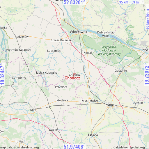
Chodecz GPS coordinates[2]
52° 24' 18.468" North, 19° 1' 39.324" East
| Map corner | latitude | longitude |
|---|---|---|
| Upper-left | 52.83201°, | 18.32447° |
| Center: | 52.40513°, | 19.02759° |
| Lower-right: | 51.97408°, | 19.73072° |
| Map W x H: | 95.4×95.4 km | = 59.3×59.3mi |
| max Lat: | 54.83135° ⇑25.2% North |
| Chodecz: | 52.40513° |
| min Lat: | ⇓74.8% South 49.21328° |
| min Long | Chodecz | max Long |
| 14.20249° | 19.02759° | 24.03723° |
| W 40.3%⇐ | ⇒59.7% E |
Elevation
Elevation of Chodecz is 129 m = 423 ft, and this is 62.4 m = 205 ft below average elevation for this country.
| Max E: |
974 m = 3196 ft | 66.4% |
| Avg. | 191.4 m = 628 ft | |
| Chodecz | 129 m = 423 ft | |
Min E: |
-3 m = -10 ft | 33.6% |
See also: Poland elevation on elevation.city.
Geographical zone
Chodecz is located in North temperate zone (between Tropic of Cancer and the Arctic Circle). Distance of this North polar circle is 1574.3 km =978.2 mi to North.| Distance of | km | miles | from Chodecz |
|---|---|---|---|
| North Pole | 4180.2 | 2597.5 | to North |
| Arctic Circle | 1574.3 | 978.2 | to North |
| Tropic Cancer | 3221 | 2001.4 | to South |
| Equator | 5826.9 | 3620.7 | to South |


Nearby cities:
15 places around Chodecz: (largest is in red/bold)
• Baruchowo
18.9 km =11.7 mi,  58°
58°
• Boniewo
11.4 km =7.1 mi,  305°
305°
• Choceń
9.1 km =5.7 mi,  353°
353°
• Chodów
17.3 km =10.7 mi,  183°
183°
• Czerniewice
12.5 km =7.8 mi,  18°
18°
• Dąbrowice
11.1 km =6.9 mi,  159°
159°
• Izbica Kujawska
18 km =11.2 mi,  275°
275°
• Kaliska
6.2 km =3.9 mi,  86°
86°
• Kowal
16.1 km =10 mi,  30°
30°
• Kłodawa
18.5 km =11.5 mi,  204°
204°
• Lubień Kujawski
9.3 km =5.8 mi, 89°
• Nowe Ostrowy
15.9 km =9.9 mi,  135°
135°
• Ostrowy
14.6 km =9.1 mi, 140°
• Przedecz
11.7 km =7.3 mi,  227°
227°
• Łanięta
17.8 km =11.1 mi,  105°
105°
Sources, notices
• [Note1] Compared only with cities in Poland existing in our database
• [Src1] Map data: © OpenStreetMap contributors (CC-BY-SA)
• [Src2] Other city data from geonames.org with taken over terms of usage.
• [Src3] Geographical zone / Annual Mean Temperature by Robert A. Rohde @ Wikipedia
