Ostrowy geodata
Ostrowy (Łódź Voivodeship) is a populated place; located in Poland in Europe/Warsaw (GMT+2) time zone. With population of 1,200 people, there are 2164 cities with bigger population in this country. Compared to other cities in Poland, 72.6% of cities are located further ↓South; 56.8% of cities are located further →East and 68.9% of cities have higher elevation than Ostrowy. Note1
Administrative division(s):
- Level 1: Łódź Voivodeship
- Level 2: Powiat kutnowski
- Level 3: Nowe Ostrowy


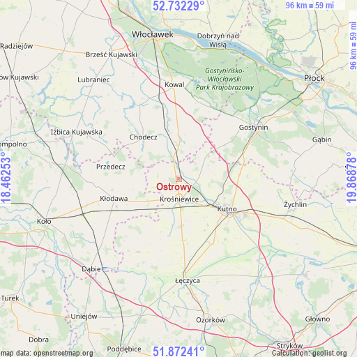
Ostrowy GPS coordinates[2]
52° 18' 15.984" North, 19° 9' 56.34" East
| Map corner | latitude | longitude |
|---|---|---|
| Upper-left | 52.73229°, | 18.46253° |
| Center: | 52.30444°, | 19.16565° |
| Lower-right: | 51.87241°, | 19.86878° |
| Map W x H: | 95.6×95.6 km | = 59.4×59.4mi |
| max Lat: | 54.83135° ⇑27.4% North |
| Ostrowy: | 52.30444° |
| min Lat: | ⇓72.6% South 49.21328° |
| min Long | Ostrowy | max Long |
| 14.20249° | 19.16565° | 24.03723° |
| W 43.2%⇐ | ⇒56.8% E |
Elevation
Elevation of Ostrowy is 123 m = 404 ft, and this is 68.4 m = 224 ft below average elevation for this country.
| Max E: |
974 m = 3196 ft | 68.9% |
| Avg. | 191.4 m = 628 ft | |
| Ostrowy | 123 m = 404 ft | |
Min E: |
-3 m = -10 ft | 31.1% |
See also: Poland elevation on elevation.city.
Geographical zone
Ostrowy is located in North temperate zone (between Tropic of Cancer and the Arctic Circle). Distance of this North polar circle is 1585.5 km =985.2 mi to North.| Distance of | km | miles | from Ostrowy |
|---|---|---|---|
| North Pole | 4191.4 | 2604.4 | to North |
| Arctic Circle | 1585.5 | 985.2 | to North |
| Tropic Cancer | 3209.8 | 1994.5 | to South |
| Equator | 5815.7 | 3613.7 | to South |


Nearby cities:
15 places around Ostrowy: (largest is in red/bold)
• Baruchowo
22.1 km =13.7 mi,  17°
17°
• Chodecz
14.6 km =9.1 mi,  320°
320°
• Chodów
12.1 km =7.5 mi,  239°
239°
• Daszyna
16.6 km =10.3 mi,  176°
176°
• Dąbrowice
5.6 km =3.5 mi,  277°
277°
• Kaliska
11.9 km =7.4 mi,  344°
344°
• Krośniewice
5.4 km =3.4 mi, 176°
• Kutno
15.8 km =9.8 mi,  121°
121°
• Kłodawa
18 km =11.2 mi,  252°
252°
• Lubień Kujawski
11.3 km =7 mi,  359°
359°
• Nowe Ostrowy
1.8 km =1.1 mi,  94°
94°
• Przedecz
18.4 km =11.4 mi, 280°
• Strzelce
16.4 km =10.2 mi, 85°
• Witonia
19.8 km =12.3 mi,  152°
152°
• Łanięta
10.1 km =6.3 mi,  50°
50°
Sources, notices
• [Note1] Compared only with cities in Poland existing in our database
• [Src1] Map data: © OpenStreetMap contributors (CC-BY-SA)
• [Src2] Other city data from geonames.org with taken over terms of usage.
• [Src3] Geographical zone / Annual Mean Temperature by Robert A. Rohde @ Wikipedia
