Czerniewice geodata
Czerniewice (Kujawsko-Pomorskie) is a populated place; located in Poland in Europe/Warsaw (GMT+2) time zone. With population of 1,027 people, there are 2423 cities with bigger population in this country. Compared to other cities in Poland, 76.7% of cities are located further ↓South; 58.6% of cities are located further →East and 78.4% of cities have higher elevation than Czerniewice. Note1


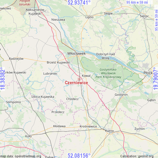
Czerniewice GPS coordinates[2]
52° 30' 41.652" North, 19° 5' 12.984" East
| Map corner | latitude | longitude |
|---|---|---|
| Upper-left | 52.93741°, | 18.38382° |
| Center: | 52.51157°, | 19.08694° |
| Lower-right: | 52.08156°, | 19.79007° |
| Map W x H: | 95.2×95.2 km | = 59.2×59.2mi |
| max Lat: | 54.83135° ⇑23.3% North |
| Czerniewice: | 52.51157° |
| min Lat: | ⇓76.7% South 49.21328° |
| min Long | Czerniewice | max Long |
| 14.20249° | 19.08694° | 24.03723° |
| W 41.4%⇐ | ⇒58.6% E |
Elevation
Elevation of Czerniewice is 103 m = 338 ft, and this is 88.4 m = 290 ft below average elevation for this country.
| Max E: |
974 m = 3196 ft | 78.4% |
| Avg. | 191.4 m = 628 ft | |
| Czerniewice | 103 m = 338 ft | |
Min E: |
-3 m = -10 ft | 21.6% |
See also: Poland elevation on elevation.city.
Geographical zone
Czerniewice is located in North temperate zone (between Tropic of Cancer and the Arctic Circle). Distance of this North polar circle is 1562.4 km =970.8 mi to North.| Distance of | km | miles | from Czerniewice |
|---|---|---|---|
| North Pole | 4168.3 | 2590.1 | to North |
| Arctic Circle | 1562.4 | 970.8 | to North |
| Tropic Cancer | 3232.8 | 2008.8 | to South |
| Equator | 5838.7 | 3628 | to South |


Nearby cities:
15 places around Czerniewice: (largest is in red/bold)
• Baruchowo
12.2 km =7.6 mi,  99°
99°
• Boniewo
14.2 km =8.8 mi,  248°
248°
• Brześć Kujawski
16.3 km =10.1 mi,  309°
309°
• Choceń
5.7 km =3.5 mi,  240°
240°
• Chodecz
12.5 km =7.8 mi,  198°
198°
• Dobrzyń nad Wisłą
21.1 km =13.1 mi,  48°
48°
• Dąbrowice
22.3 km =13.9 mi,  180°
180°
• Fabianki
23.1 km =14.4 mi,  3°
3°
• Kaliska
11.7 km =7.3 mi,  169°
169°
• Kowal
4.6 km =2.9 mi,  63°
63°
• Lubień Kujawski
12.9 km =8 mi,  155°
155°
• Lubraniec
17.5 km =10.9 mi,  281°
281°
• Przedecz
23.5 km =14.6 mi,  212°
212°
• Włocławek
15.2 km =9.4 mi,  355°
355°
• Łanięta
21.2 km =13.2 mi,  141°
141°
Sources, notices
• [Note1] Compared only with cities in Poland existing in our database
• [Src1] Map data: © OpenStreetMap contributors (CC-BY-SA)
• [Src2] Other city data from geonames.org with taken over terms of usage.
• [Src3] Geographical zone / Annual Mean Temperature by Robert A. Rohde @ Wikipedia
