Szczawin geodata
Szczawin (Łódź Voivodeship) is a populated place; located in Poland in Europe/Warsaw (GMT+2) time zone. With population of 630 people, there are 3202 cities with bigger population in this country. Compared to other cities in Poland, 63.6% of cities are located further ↓South; 51.2% of cities are located further →East and 56.4% of cities have higher elevation than Szczawin. Note1


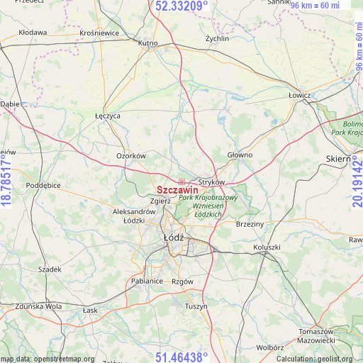
Szczawin GPS coordinates[2]
51° 54' 1.188" North, 19° 29' 17.844" East
| Map corner | latitude | longitude |
|---|---|---|
| Upper-left | 52.33209°, | 18.78517° |
| Center: | 51.90033°, | 19.48829° |
| Lower-right: | 51.46438°, | 20.19142° |
| Map W x H: | 96.5×96.5 km | = 60×60mi |
| max Lat: | 54.83135° ⇑36.4% North |
| Szczawin: | 51.90033° |
| min Lat: | ⇓63.6% South 49.21328° |
| min Long | Szczawin | max Long |
| 14.20249° | 19.48829° | 24.03723° |
| W 48.8%⇐ | ⇒51.2% E |
Elevation
Elevation of Szczawin is 155 m = 509 ft, and this is 36.4 m = 119 ft below average elevation for this country.
| Max E: |
974 m = 3196 ft | 56.4% |
| Avg. | 191.4 m = 628 ft | |
| Szczawin | 155 m = 509 ft | |
Min E: |
-3 m = -10 ft | 43.6% |
See also: Poland elevation on elevation.city.
Geographical zone
Szczawin is located in North temperate zone (between Tropic of Cancer and the Arctic Circle). Distance of this North polar circle is 1630.4 km =1013.1 mi to North.| Distance of | km | miles | from Szczawin |
|---|---|---|---|
| North Pole | 4236.3 | 2632.3 | to North |
| Arctic Circle | 1630.4 | 1013.1 | to North |
| Tropic Cancer | 3164.9 | 1966.6 | to South |
| Equator | 5770.8 | 3585.8 | to South |


Nearby cities:
15 places around Szczawin: (largest is in red/bold)
• Aleksandrów Łódzki
15.5 km =9.6 mi,  234°
234°
• Andrespol
21.9 km =13.6 mi,  151°
151°
• Bielawy
22.6 km =14 mi,  30°
30°
• Brzeziny
21.2 km =13.2 mi,  121°
121°
• Dmosin
18.8 km =11.7 mi,  81°
81°
• Dobra
6.1 km =3.8 mi, 123°
• Góra Świętej Małgorzaty
20.9 km =13 mi,  326°
326°
• Głowno
17.1 km =10.6 mi,  65°
65°
• Konstantynów Łódzki
20.3 km =12.6 mi,  213°
213°
• Ozorków
15.2 km =9.4 mi,  297°
297°
• Parzęczew
20.1 km =12.5 mi,  285°
285°
• Piątek
18.8 km =11.7 mi,  358°
358°
• Stryków
8 km =5 mi,  88°
88°
• Zgierz
7.5 km =4.7 mi, 228°
• Łódź
14.5 km =9 mi,  183°
183°
Sources, notices
• [Note1] Compared only with cities in Poland existing in our database
• [Src1] Map data: © OpenStreetMap contributors (CC-BY-SA)
• [Src2] Other city data from geonames.org with taken over terms of usage.
• [Src3] Geographical zone / Annual Mean Temperature by Robert A. Rohde @ Wikipedia
