Dobra geodata
Dobra (Łódź Voivodeship) is a populated place; located in Poland in Europe/Warsaw (GMT+2) time zone. With population of 510 people, there are 3513 cities with bigger population in this country. Compared to other cities in Poland, 63.1% of cities are located further ↓South; 50% of cities are located further ←West and 52.3% of cities have lower elevation than Dobra. Note1


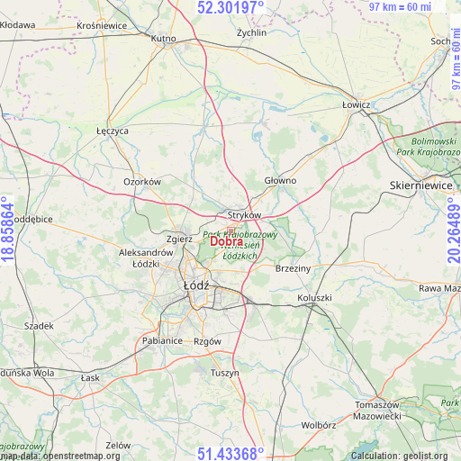
Dobra GPS coordinates[2]
51° 52' 11.712" North, 19° 33' 42.336" East
| Map corner | latitude | longitude |
|---|---|---|
| Upper-left | 52.30197°, | 18.85864° |
| Center: | 51.86992°, | 19.56176° |
| Lower-right: | 51.43368°, | 20.26489° |
| Map W x H: | 96.5×96.5 km | = 60×60mi |
| max Lat: | 54.83135° ⇑36.9% North |
| Dobra: | 51.86992° |
| min Lat: | ⇓63.1% South 49.21328° |
| min Long | Dobra | max Long |
| 14.20249° | 19.56176° | 24.03723° |
| W 50%⇐ | ⇒50% E |
Elevation
Elevation of Dobra is 178 m = 584 ft, and this is 13.4 m = 44 ft below average elevation for this country.
| Max E: |
974 m = 3196 ft | 47.7% |
| Avg. | 191.4 m = 628 ft | |
| Dobra | 178 m = 584 ft | |
Min E: |
-3 m = -10 ft | 52.3% |
See also: Poland elevation on elevation.city.
Geographical zone
Dobra is located in North temperate zone (between Tropic of Cancer and the Arctic Circle). Distance of this North polar circle is 1633.8 km =1015.2 mi to North.| Distance of | km | miles | from Dobra |
|---|---|---|---|
| North Pole | 4239.7 | 2634.4 | to North |
| Arctic Circle | 1633.8 | 1015.2 | to North |
| Tropic Cancer | 3161.5 | 1964.5 | to South |
| Equator | 5767.4 | 3583.7 | to South |


Nearby cities:
15 places around Dobra: (largest is in red/bold)
• Aleksandrów Łódzki
18.6 km =11.6 mi,  252°
252°
• Andrespol
16.7 km =10.4 mi,  160°
160°
• Brzeziny
15.2 km =9.4 mi,  120°
120°
• Dmosin
14.8 km =9.2 mi,  65°
65°
• Gałków Duży
18.6 km =11.6 mi,  143°
143°
• Gałków Mały
19.1 km =11.9 mi,  146°
146°
• Głowno
14.9 km =9.3 mi,  45°
45°
• Konstantynów Łódzki
21.2 km =13.2 mi,  230°
230°
• Ozorków
21.3 km =13.2 mi,  299°
299°
• Starowa Góra
20.6 km =12.8 mi,  195°
195°
• Stryków
4.7 km =2.9 mi,  39°
39°
• Szczawin
6.1 km =3.8 mi, 303°
• Wola Rakowa
22.2 km =13.8 mi,  171°
171°
• Zgierz
10.8 km =6.7 mi,  261°
261°
• Łódź
12.6 km =7.8 mi,  208°
208°
Sources, notices
• [Note1] Compared only with cities in Poland existing in our database
• [Src1] Map data: © OpenStreetMap contributors (CC-BY-SA)
• [Src2] Other city data from geonames.org with taken over terms of usage.
• [Src3] Geographical zone / Annual Mean Temperature by Robert A. Rohde @ Wikipedia
