Lisków geodata
Lisków (Greater Poland) is a populated place; located in Poland in Europe/Warsaw (GMT+2) time zone. With population of 1,858 people, there are 1578 cities with bigger population in this country. Compared to other cities in Poland, 62.6% of cities are located further ↓South; 69.8% of cities are located further →East and 62.1% of cities have higher elevation than Lisków. Note1


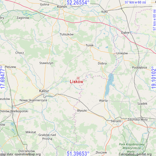
Lisków GPS coordinates[2]
51° 49' 59.268" North, 18° 23' 52.404" East
| Map corner | latitude | longitude |
|---|---|---|
| Upper-left | 52.26554°, | 17.69477° |
| Center: | 51.83313°, | 18.39789° |
| Lower-right: | 51.39653°, | 19.10102° |
| Map W x H: | 96.6×96.6 km | = 60×60mi |
| max Lat: | 54.83135° ⇑37.4% North |
| Lisków: | 51.83313° |
| min Lat: | ⇓62.6% South 49.21328° |
| min Long | Lisków | max Long |
| 14.20249° | 18.39789° | 24.03723° |
| W 30.2%⇐ | ⇒69.8% E |
Elevation
Elevation of Lisków is 142 m = 466 ft, and this is 49.4 m = 162 ft below average elevation for this country.
| Max E: |
974 m = 3196 ft | 62.1% |
| Avg. | 191.4 m = 628 ft | |
| Lisków | 142 m = 466 ft | |
Min E: |
-3 m = -10 ft | 37.9% |
See also: Poland elevation on elevation.city.
Geographical zone
Lisków is located in North temperate zone (between Tropic of Cancer and the Arctic Circle). Distance of this North polar circle is 1637.9 km =1017.7 mi to North.| Distance of | km | miles | from Lisków |
|---|---|---|---|
| North Pole | 4243.8 | 2637 | to North |
| Arctic Circle | 1637.9 | 1017.7 | to North |
| Tropic Cancer | 3157.4 | 1961.9 | to South |
| Equator | 5763.3 | 3581.1 | to South |


Nearby cities:
15 places around Lisków: (largest is in red/bold)
• Borysławice
20.2 km =12.6 mi,  174°
174°
• Błaszki
20.3 km =12.6 mi, 172°
• Dobra
17.6 km =10.9 mi,  58°
58°
• Dębe
14.6 km =9.1 mi,  255°
255°
• Goszczanów
8.7 km =5.4 mi,  121°
121°
• Kawęczyn
12.5 km =7.8 mi,  47°
47°
• Kościelec
15.1 km =9.4 mi,  303°
303°
• Koźminek
5.6 km =3.5 mi,  226°
226°
• Malanów
13.4 km =8.3 mi,  358°
358°
• Opatówek
16.2 km =10.1 mi, 230°
• Stawiszyn
21.8 km =13.5 mi, 295°
• Szczytniki
16.7 km =10.4 mi,  195°
195°
• Turek
21.5 km =13.4 mi,  19°
19°
• Warta
20.7 km =12.9 mi,  131°
131°
• Żelazków
15.5 km =9.6 mi,  278°
278°
Sources, notices
• [Note1] Compared only with cities in Poland existing in our database
• [Src1] Map data: © OpenStreetMap contributors (CC-BY-SA)
• [Src2] Other city data from geonames.org with taken over terms of usage.
• [Src3] Geographical zone / Annual Mean Temperature by Robert A. Rohde @ Wikipedia
