Koźminek geodata
Koźminek (Greater Poland) is a populated place; located in Poland in Europe/Warsaw (GMT+2) time zone. With population of 1,800 people, there are 1605 cities with bigger population in this country. Compared to other cities in Poland, 62.1% of cities are located further ↓South; 70.7% of cities are located further →East and 67.1% of cities have higher elevation than Koźminek. Note1


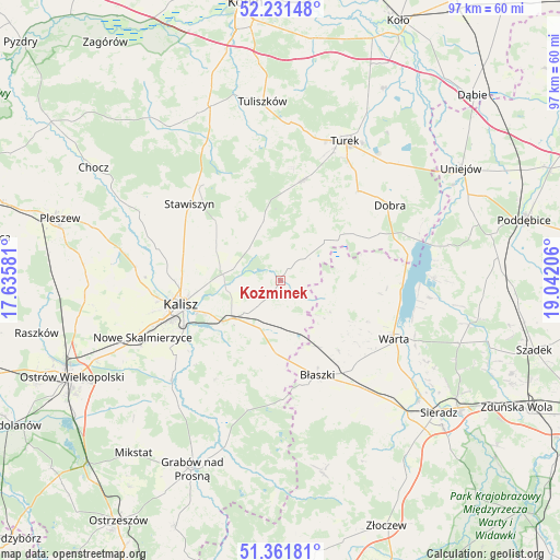
Koźminek GPS coordinates[2]
51° 47' 55.464" North, 18° 20' 20.148" East
| Map corner | latitude | longitude |
|---|---|---|
| Upper-left | 52.23148°, | 17.63581° |
| Center: | 51.79874°, | 18.33893° |
| Lower-right: | 51.36181°, | 19.04206° |
| Map W x H: | 96.7×96.7 km | = 60.1×60.1mi |
| max Lat: | 54.83135° ⇑37.9% North |
| Koźminek: | 51.79874° |
| min Lat: | ⇓62.1% South 49.21328° |
| min Long | Koźminek | max Long |
| 14.20249° | 18.33893° | 24.03723° |
| W 29.3%⇐ | ⇒70.7% E |
Elevation
Elevation of Koźminek is 128 m = 420 ft, and this is 63.4 m = 208 ft below average elevation for this country.
| Max E: |
974 m = 3196 ft | 67.1% |
| Avg. | 191.4 m = 628 ft | |
| Koźminek | 128 m = 420 ft | |
Min E: |
-3 m = -10 ft | 32.9% |
See also: Poland elevation on elevation.city.
Geographical zone
Koźminek is located in North temperate zone (between Tropic of Cancer and the Arctic Circle). Distance of this North polar circle is 1641.7 km =1020.1 mi to North.| Distance of | km | miles | from Koźminek |
|---|---|---|---|
| North Pole | 4247.6 | 2639.3 | to North |
| Arctic Circle | 1641.7 | 1020.1 | to North |
| Tropic Cancer | 3153.6 | 1959.6 | to South |
| Equator | 5759.5 | 3578.8 | to South |


Nearby cities:
15 places around Koźminek: (largest is in red/bold)
• Borysławice
17.3 km =10.7 mi,  159°
159°
• Błaszki
17.6 km =10.9 mi, 158°
• Dębe
10.1 km =6.3 mi,  270°
270°
• Godziesze Wielkie
20.6 km =12.8 mi,  213°
213°
• Goszczanów
11.5 km =7.1 mi,  93°
93°
• Kalisz
17.6 km =10.9 mi,  256°
256°
• Kawęczyn
18 km =11.2 mi,  47°
47°
• Kościelec
14.8 km =9.2 mi,  324°
324°
• Lisków
5.6 km =3.5 mi, 46°
• Malanów
17.6 km =10.9 mi,  11°
11°
• Opatówek
10.7 km =6.6 mi,  232°
232°
• Stawiszyn
20.5 km =12.7 mi,  310°
310°
• Szczytniki
12.2 km =7.6 mi,  182°
182°
• Warta
22 km =13.7 mi,  116°
116°
• Żelazków
12.9 km =8 mi,  298°
298°
Sources, notices
• [Note1] Compared only with cities in Poland existing in our database
• [Src1] Map data: © OpenStreetMap contributors (CC-BY-SA)
• [Src2] Other city data from geonames.org with taken over terms of usage.
• [Src3] Geographical zone / Annual Mean Temperature by Robert A. Rohde @ Wikipedia
