Dobra geodata
Dobra (Greater Poland) is a seat of a third-order administrative division; located in Poland in Europe/Warsaw (GMT+2) time zone. With population of 1,450 people, there are 1914 cities with bigger population in this country. Compared to other cities in Poland, 64% of cities are located further ↓South; 66.3% of cities are located further →East and 70.4% of cities have higher elevation than Dobra. Note1


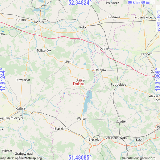
Dobra GPS coordinates[2]
51° 54' 59.904" North, 18° 36' 56.016" East
| Map corner | latitude | longitude |
|---|---|---|
| Upper-left | 52.34824°, | 17.91244° |
| Center: | 51.91664°, | 18.61556° |
| Lower-right: | 51.48085°, | 19.31869° |
| Map W x H: | 96.4×96.4 km | = 59.9×59.9mi |
| max Lat: | 54.83135° ⇑36% North |
| Dobra: | 51.91664° |
| min Lat: | ⇓64% South 49.21328° |
| min Long | Dobra | max Long |
| 14.20249° | 18.61556° | 24.03723° |
| W 33.7%⇐ | ⇒66.3% E |
Elevation
Elevation of Dobra is 120 m = 394 ft, and this is 71.4 m = 234 ft below average elevation for this country.
| Max E: |
974 m = 3196 ft | 70.4% |
| Avg. | 191.4 m = 628 ft | |
| Dobra | 120 m = 394 ft | |
Min E: |
-3 m = -10 ft | 29.6% |
See also: Poland elevation on elevation.city.
Geographical zone
Dobra is located in North temperate zone (between Tropic of Cancer and the Arctic Circle). Distance of this North polar circle is 1628.6 km =1012 mi to North.| Distance of | km | miles | from Dobra |
|---|---|---|---|
| North Pole | 4234.5 | 2631.2 | to North |
| Arctic Circle | 1628.6 | 1012 | to North |
| Tropic Cancer | 3166.7 | 1967.7 | to South |
| Equator | 5772.6 | 3586.9 | to South |


Nearby cities:
15 places around Dobra: (largest is in red/bold)
• Brudzew
20.3 km =12.6 mi,  357°
357°
• Dąbie
23.6 km =14.7 mi,  36°
36°
• Goszczanów
15.8 km =9.8 mi,  208°
208°
• Kawęczyn
5.9 km =3.7 mi,  261°
261°
• Koźminek
23.1 km =14.4 mi,  235°
235°
• Lisków
17.6 km =10.9 mi, 238°
• Malanów
15.9 km =9.9 mi,  284°
284°
• Poddębice
23.6 km =14.7 mi,  96°
96°
• Przykona
7.2 km =4.5 mi, 358°
• Pęczniew
14.6 km =9.1 mi,  149°
149°
• Turek
13.5 km =8.4 mi,  324°
324°
• Uniejów
13.8 km =8.6 mi,  62°
62°
• Warta
22.9 km =14.2 mi,  178°
178°
• Władysławów
22.8 km =14.2 mi,  335°
335°
• Zadzim
22.4 km =13.9 mi,  134°
134°
Sources, notices
• [Note1] Compared only with cities in Poland existing in our database
• [Src1] Map data: © OpenStreetMap contributors (CC-BY-SA)
• [Src2] Other city data from geonames.org with taken over terms of usage.
• [Src3] Geographical zone / Annual Mean Temperature by Robert A. Rohde @ Wikipedia
