Kościelec geodata
Kościelec (Greater Poland) is a populated place; located in Poland in Europe/Warsaw (GMT+2) time zone. With population of 600 people, there are 3270 cities with bigger population in this country. Compared to other cities in Poland, 63.8% of cities are located further ↓South; 72.4% of cities are located further →East and 65.2% of cities have higher elevation than Kościelec. Note1


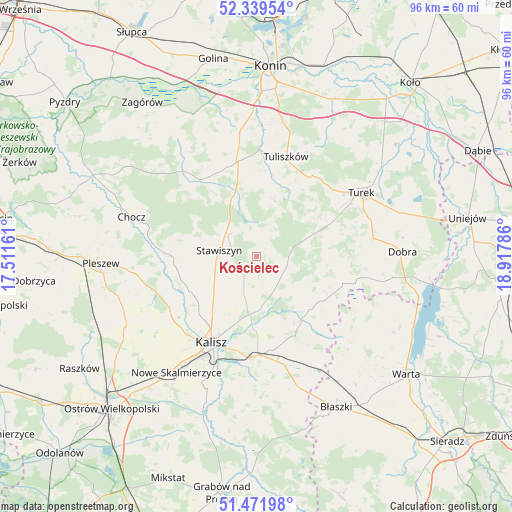
Kościelec GPS coordinates[2]
51° 54' 28.26" North, 18° 12' 53.028" East
| Map corner | latitude | longitude |
|---|---|---|
| Upper-left | 52.33954°, | 17.51161° |
| Center: | 51.90785°, | 18.21473° |
| Lower-right: | 51.47198°, | 18.91786° |
| Map W x H: | 96.5×96.5 km | = 60×60mi |
| max Lat: | 54.83135° ⇑36.2% North |
| Kościelec: | 51.90785° |
| min Lat: | ⇓63.8% South 49.21328° |
| min Long | Kościelec | max Long |
| 14.20249° | 18.21473° | 24.03723° |
| W 27.6%⇐ | ⇒72.4% E |
Elevation
Elevation of Kościelec is 132 m = 433 ft, and this is 59.4 m = 195 ft below average elevation for this country.
| Max E: |
974 m = 3196 ft | 65.2% |
| Avg. | 191.4 m = 628 ft | |
| Kościelec | 132 m = 433 ft | |
Min E: |
-3 m = -10 ft | 34.8% |
See also: Poland elevation on elevation.city.
Geographical zone
Kościelec is located in North temperate zone (between Tropic of Cancer and the Arctic Circle). Distance of this North polar circle is 1629.6 km =1012.6 mi to North.| Distance of | km | miles | from Kościelec |
|---|---|---|---|
| North Pole | 4235.5 | 2631.8 | to North |
| Arctic Circle | 1629.6 | 1012.6 | to North |
| Tropic Cancer | 3165.7 | 1967.1 | to South |
| Equator | 5771.6 | 3586.3 | to South |


Nearby cities:
15 places around Kościelec: (largest is in red/bold)
• Blizanów
14 km =8.7 mi,  268°
268°
• Dębe
12.1 km =7.5 mi,  187°
187°
• Gołuchów
20.5 km =12.7 mi,  251°
251°
• Grodziec
18 km =11.2 mi,  323°
323°
• Kalisz
18.4 km =11.4 mi,  207°
207°
• Kawęczyn
21.7 km =13.5 mi,  89°
89°
• Koźminek
14.8 km =9.2 mi,  144°
144°
• Lisków
15.1 km =9.4 mi,  123°
123°
• Malanów
13.1 km =8.1 mi,  67°
67°
• Opatówek
18.7 km =11.6 mi,  179°
179°
• Rychwał
18.5 km =11.5 mi,  349°
349°
• Stawiszyn
7.2 km =4.5 mi,  278°
278°
• Tuliszków
19.6 km =12.2 mi,  16°
16°
• Turek
22.9 km =14.2 mi,  58°
58°
• Żelazków
6.6 km =4.1 mi,  204°
204°
Sources, notices
• [Note1] Compared only with cities in Poland existing in our database
• [Src1] Map data: © OpenStreetMap contributors (CC-BY-SA)
• [Src2] Other city data from geonames.org with taken over terms of usage.
• [Src3] Geographical zone / Annual Mean Temperature by Robert A. Rohde @ Wikipedia
