Żelazków geodata
Żelazków (Greater Poland) is a populated place; located in Poland in Europe/Warsaw (GMT+2) time zone. With population of 1,250 people, there are 2126 cities with bigger population in this country. Compared to other cities in Poland, 62.8% of cities are located further ↓South; 72.9% of cities are located further →East and 68.6% of cities have higher elevation than Żelazków. Note1


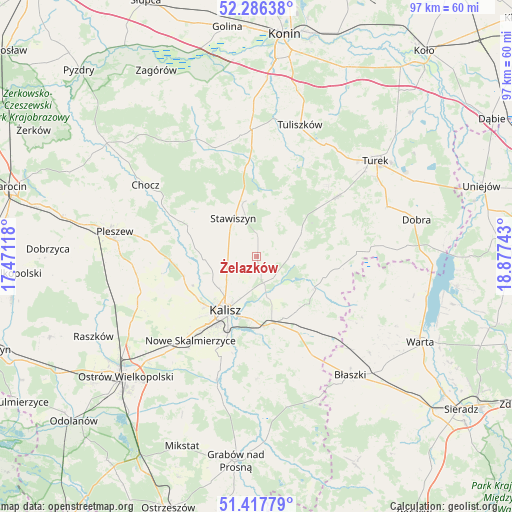
Żelazków GPS coordinates[2]
51° 51' 15.048" North, 18° 10' 27.48" East
| Map corner | latitude | longitude |
|---|---|---|
| Upper-left | 52.28638°, | 17.47118° |
| Center: | 51.85418°, | 18.1743° |
| Lower-right: | 51.41779°, | 18.87743° |
| Map W x H: | 96.6×96.6 km | = 60×60mi |
| max Lat: | 54.83135° ⇑37.2% North |
| Żelazków: | 51.85418° |
| min Lat: | ⇓62.8% South 49.21328° |
| min Long | Żelazków | max Long |
| 14.20249° | 18.1743° | 24.03723° |
| W 27.1%⇐ | ⇒72.9% E |
Elevation
Elevation of Żelazków is 124 m = 407 ft, and this is 67.4 m = 221 ft below average elevation for this country.
| Max E: |
974 m = 3196 ft | 68.6% |
| Avg. | 191.4 m = 628 ft | |
| Żelazków | 124 m = 407 ft | |
Min E: |
-3 m = -10 ft | 31.4% |
See also: Poland elevation on elevation.city.
Geographical zone
Żelazków is located in North temperate zone (between Tropic of Cancer and the Arctic Circle). Distance of this North polar circle is 1635.5 km =1016.3 mi to North.| Distance of | km | miles | from Żelazków |
|---|---|---|---|
| North Pole | 4241.4 | 2635.5 | to North |
| Arctic Circle | 1635.5 | 1016.3 | to North |
| Tropic Cancer | 3159.7 | 1963.3 | to South |
| Equator | 5765.6 | 3582.6 | to South |


Nearby cities:
15 places around Żelazków: (largest is in red/bold)
• Blizanów
12.5 km =7.8 mi,  296°
296°
• Dębe
6.2 km =3.9 mi,  168°
168°
• Gołuchów
16.7 km =10.4 mi,  268°
268°
• Grodziec
22 km =13.7 mi,  339°
339°
• Kalisz
11.8 km =7.3 mi,  208°
208°
• Kościelec
6.6 km =4.1 mi,  24°
24°
• Koźminek
12.9 km =8 mi,  118°
118°
• Lisków
15.5 km =9.6 mi,  98°
98°
• Malanów
18.5 km =11.5 mi,  53°
53°
• Nowe Skalmierzyce
20.3 km =12.6 mi,  217°
217°
• Opatówek
13 km =8.1 mi, 167°
• Skalmierzyce
22.4 km =13.9 mi, 220°
• Sobótka
23.2 km =14.4 mi,  249°
249°
• Stawiszyn
8.3 km =5.2 mi,  328°
328°
• Szczytniki
21.3 km =13.2 mi,  149°
149°
Sources, notices
• [Note1] Compared only with cities in Poland existing in our database
• [Src1] Map data: © OpenStreetMap contributors (CC-BY-SA)
• [Src2] Other city data from geonames.org with taken over terms of usage.
• [Src3] Geographical zone / Annual Mean Temperature by Robert A. Rohde @ Wikipedia
