Stawiszyn geodata
Stawiszyn (Greater Poland) is a populated place; located in Poland in Europe/Warsaw (GMT+2) time zone. With population of 1,564 people, there are 1794 cities with bigger population in this country. Compared to other cities in Poland, 64.1% of cities are located further ↓South; 74% of cities are located further →East and 70.4% of cities have higher elevation than Stawiszyn. Note1


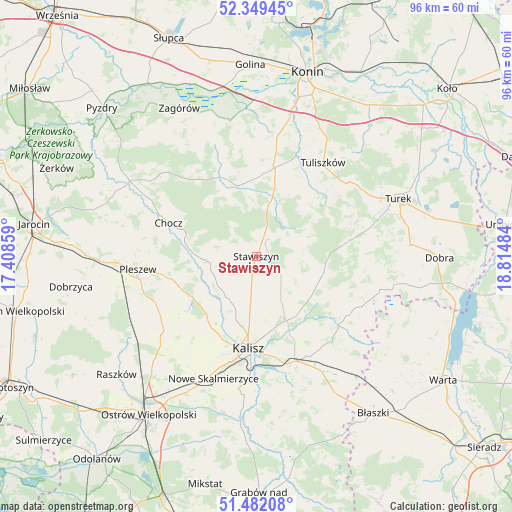
Stawiszyn GPS coordinates[2]
51° 55' 4.296" North, 18° 6' 42.156" East
| Map corner | latitude | longitude |
|---|---|---|
| Upper-left | 52.34945°, | 17.40859° |
| Center: | 51.91786°, | 18.11171° |
| Lower-right: | 51.48208°, | 18.81484° |
| Map W x H: | 96.4×96.4 km | = 59.9×59.9mi |
| max Lat: | 54.83135° ⇑35.9% North |
| Stawiszyn: | 51.91786° |
| min Lat: | ⇓64.1% South 49.21328° |
| min Long | Stawiszyn | max Long |
| 14.20249° | 18.11171° | 24.03723° |
| W 26%⇐ | ⇒74% E |
Elevation
Elevation of Stawiszyn is 120 m = 394 ft, and this is 71.4 m = 234 ft below average elevation for this country.
| Max E: |
974 m = 3196 ft | 70.4% |
| Avg. | 191.4 m = 628 ft | |
| Stawiszyn | 120 m = 394 ft | |
Min E: |
-3 m = -10 ft | 29.6% |
See also: Poland elevation on elevation.city.
Geographical zone
Stawiszyn is located in North temperate zone (between Tropic of Cancer and the Arctic Circle). Distance of this North polar circle is 1628.4 km =1011.8 mi to North.| Distance of | km | miles | from Stawiszyn |
|---|---|---|---|
| North Pole | 4234.3 | 2631.1 | to North |
| Arctic Circle | 1628.4 | 1011.8 | to North |
| Tropic Cancer | 3166.8 | 1967.8 | to South |
| Equator | 5772.7 | 3587 | to South |


Nearby cities:
15 places around Stawiszyn: (largest is in red/bold)
• Blizanów
7.1 km =4.4 mi,  257°
257°
• Broniszewice
21 km =13 mi,  285°
285°
• Chocz
17.8 km =11.1 mi, 291°
• Dębe
14.3 km =8.9 mi,  157°
157°
• Gołuchów
14.5 km =9 mi,  238°
238°
• Grodziec
13.9 km =8.6 mi,  345°
345°
• Kalisz
17.5 km =10.9 mi,  184°
184°
• Kościelec
7.2 km =4.5 mi,  98°
98°
• Koźminek
20.5 km =12.7 mi,  130°
130°
• Lisków
21.8 km =13.5 mi,  115°
115°
• Malanów
19.6 km =12.2 mi,  78°
78°
• Opatówek
21.1 km =13.1 mi, 159°
• Rychwał
17.5 km =10.9 mi,  12°
12°
• Tuliszków
21.7 km =13.5 mi,  35°
35°
• Żelazków
8.3 km =5.2 mi,  148°
148°
Sources, notices
• [Note1] Compared only with cities in Poland existing in our database
• [Src1] Map data: © OpenStreetMap contributors (CC-BY-SA)
• [Src2] Other city data from geonames.org with taken over terms of usage.
• [Src3] Geographical zone / Annual Mean Temperature by Robert A. Rohde @ Wikipedia
