Malanów geodata
Malanów (Greater Poland) is a populated place; located in Poland in Europe/Warsaw (GMT+2) time zone. With population of 1,607 people, there are 1747 cities with bigger population in this country. Compared to other cities in Poland, 64.7% of cities are located further ↓South; 69.9% of cities are located further →East and 50.8% of cities have higher elevation than Malanów. Note1


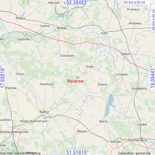
Malanów GPS coordinates[2]
51° 57' 12.888" North, 18° 23' 28.608" East
| Map corner | latitude | longitude |
|---|---|---|
| Upper-left | 52.38482°, | 17.68816° |
| Center: | 51.95358°, | 18.39128° |
| Lower-right: | 51.51815°, | 19.09441° |
| Map W x H: | 96.4×96.4 km | = 59.9×59.9mi |
| max Lat: | 54.83135° ⇑35.3% North |
| Malanów: | 51.95358° |
| min Lat: | ⇓64.7% South 49.21328° |
| min Long | Malanów | max Long |
| 14.20249° | 18.39128° | 24.03723° |
| W 30.1%⇐ | ⇒69.9% E |
Elevation
Elevation of Malanów is 170 m = 558 ft, and this is 21.4 m = 70 ft below average elevation for this country.
| Max E: |
974 m = 3196 ft | 50.8% |
| Avg. | 191.4 m = 628 ft | |
| Malanów | 170 m = 558 ft | |
Min E: |
-3 m = -10 ft | 49.2% |
See also: Poland elevation on elevation.city.
Geographical zone
Malanów is located in North temperate zone (between Tropic of Cancer and the Arctic Circle). Distance of this North polar circle is 1624.5 km =1009.4 mi to North.| Distance of | km | miles | from Malanów |
|---|---|---|---|
| North Pole | 4230.4 | 2628.6 | to North |
| Arctic Circle | 1624.5 | 1009.4 | to North |
| Tropic Cancer | 3170.8 | 1970.2 | to South |
| Equator | 5776.7 | 3589.5 | to South |


Nearby cities:
15 places around Malanów: (largest is in red/bold)
• Dobra
15.9 km =9.9 mi,  104°
104°
• Goszczanów
19.6 km =12.2 mi,  156°
156°
• Kawęczyn
10.8 km =6.7 mi,  117°
117°
• Kościelec
13.1 km =8.1 mi,  247°
247°
• Koźminek
17.6 km =10.9 mi,  191°
191°
• Lisków
13.4 km =8.3 mi,  178°
178°
• Przykona
15.5 km =9.6 mi,  78°
78°
• Russocice
18.7 km =11.6 mi,  19°
19°
• Rychwał
20.3 km =12.6 mi,  310°
310°
• Stawiszyn
19.6 km =12.2 mi,  258°
258°
• Tarnowa
15.8 km =9.8 mi,  355°
355°
• Tuliszków
15.2 km =9.4 mi,  334°
334°
• Turek
10.2 km =6.3 mi,  47°
47°
• Władysławów
17.6 km =10.9 mi, 19°
• Żelazków
18.5 km =11.5 mi,  233°
233°
Sources, notices
• [Note1] Compared only with cities in Poland existing in our database
• [Src1] Map data: © OpenStreetMap contributors (CC-BY-SA)
• [Src2] Other city data from geonames.org with taken over terms of usage.
• [Src3] Geographical zone / Annual Mean Temperature by Robert A. Rohde @ Wikipedia
