Lipusz geodata
Lipusz (Pomerania) is a populated place; located in Poland in Europe/Warsaw (GMT+2) time zone. With population of 2,069 people, there are 1443 cities with bigger population in this country. Compared to other cities in Poland, 95.3% of cities are located further ↓South; 77.4% of cities are located further →East and 58.4% of cities have higher elevation than Lipusz. Note1


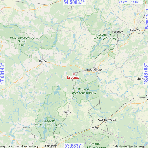
Lipusz GPS coordinates[2]
54° 5' 53.016" North, 17° 47' 4.38" East
| Map corner | latitude | longitude |
|---|---|---|
| Upper-left | 54.50833°, | 17.08143° |
| Center: | 54.09806°, | 17.78455° |
| Lower-right: | 53.6837°, | 18.48768° |
| Map W x H: | 91.7×91.7 km | = 57×57mi |
| max Lat: | 54.83135° ⇑4.7% North |
| Lipusz: | 54.09806° |
| min Lat: | ⇓95.3% South 49.21328° |
| min Long | Lipusz | max Long |
| 14.20249° | 17.78455° | 24.03723° |
| W 22.6%⇐ | ⇒77.4% E |
Elevation
Elevation of Lipusz is 150 m = 492 ft, and this is 41.4 m = 136 ft below average elevation for this country.
| Max E: |
974 m = 3196 ft | 58.4% |
| Avg. | 191.4 m = 628 ft | |
| Lipusz | 150 m = 492 ft | |
Min E: |
-3 m = -10 ft | 41.6% |
See also: Poland elevation on elevation.city.
Geographical zone
Lipusz is located in North temperate zone (between Tropic of Cancer and the Arctic Circle). Distance of this North polar circle is 1386 km =861.2 mi to North.| Distance of | km | miles | from Lipusz |
|---|---|---|---|
| North Pole | 3991.9 | 2480.5 | to North |
| Arctic Circle | 1386 | 861.2 | to North |
| Tropic Cancer | 3409.2 | 2118.4 | to South |
| Equator | 6015.1 | 3737.6 | to South |


Nearby cities:
15 places around Lipusz: (largest is in red/bold)
• Brusy
24.1 km =15 mi,  190°
190°
• Bytów
20.7 km =12.9 mi,  292°
292°
• Dziemiany
10.3 km =6.4 mi, 186°
• Grabowo Kościerskie
24.9 km =15.5 mi,  71°
71°
• Kalisz Pomorski
6.1 km =3.8 mi,  171°
171°
• Karsin
23 km =14.3 mi,  157°
157°
• Kościerzyna
13.1 km =8.1 mi,  78°
78°
• Lipnica
27.1 km =16.8 mi,  245°
245°
• Nowa Karczma
27.5 km =17.1 mi, 81°
• Parchowo
14.2 km =8.8 mi,  327°
327°
• Sierakowice
28.5 km =17.7 mi,  14°
14°
• Stara Kiszewa
27.9 km =17.3 mi,  115°
115°
• Studzienice
13.6 km =8.5 mi,  267°
267°
• Stężyca
16.4 km =10.2 mi,  42°
42°
• Sulęczyno
15 km =9.3 mi,  357°
357°
Sources, notices
• [Note1] Compared only with cities in Poland existing in our database
• [Src1] Map data: © OpenStreetMap contributors (CC-BY-SA)
• [Src2] Other city data from geonames.org with taken over terms of usage.
• [Src3] Geographical zone / Annual Mean Temperature by Robert A. Rohde @ Wikipedia
