Brusy geodata
Brusy (Pomerania) is a populated place; located in Poland in Europe/Warsaw (GMT+2) time zone. With population of 4,728 people, there are 710 cities with bigger population in this country. Compared to other cities in Poland, 93% of cities are located further ↓South; 78.1% of cities are located further →East and 59.9% of cities have higher elevation than Brusy. Note1


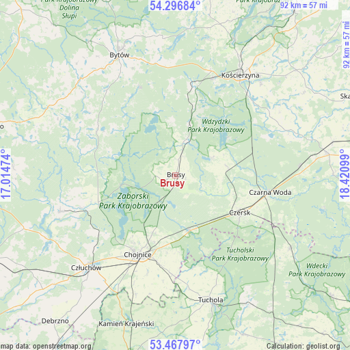
Brusy GPS coordinates[2]
53° 53' 4.056" North, 17° 43' 4.296" East
| Map corner | latitude | longitude |
|---|---|---|
| Upper-left | 54.29684°, | 17.01474° |
| Center: | 53.88446°, | 17.71786° |
| Lower-right: | 53.46797°, | 18.42099° |
| Map W x H: | 92.2×92.2 km | = 57.3×57.3mi |
| max Lat: | 54.83135° ⇑7% North |
| Brusy: | 53.88446° |
| min Lat: | ⇓93% South 49.21328° |
| min Long | Brusy | max Long |
| 14.20249° | 17.71786° | 24.03723° |
| W 21.9%⇐ | ⇒78.1% E |
Elevation
Elevation of Brusy is 147 m = 482 ft, and this is 44.4 m = 146 ft below average elevation for this country.
| Max E: |
974 m = 3196 ft | 59.9% |
| Avg. | 191.4 m = 628 ft | |
| Brusy | 147 m = 482 ft | |
Min E: |
-3 m = -10 ft | 40.1% |
See also: Poland elevation on elevation.city.
Geographical zone
Brusy is located in North temperate zone (between Tropic of Cancer and the Arctic Circle). Distance of this North polar circle is 1409.8 km =876 mi to North.| Distance of | km | miles | from Brusy |
|---|---|---|---|
| North Pole | 4015.7 | 2495.2 | to North |
| Arctic Circle | 1409.8 | 876 | to North |
| Tropic Cancer | 3385.5 | 2103.7 | to South |
| Equator | 5991.4 | 3722.9 | to South |


Nearby cities:
15 places around Brusy: (largest is in red/bold)
• Chojnice
23.5 km =14.6 mi,  206°
206°
• Czarna Woda
25.4 km =15.8 mi,  100°
100°
• Czersk
19.6 km =12.2 mi,  120°
120°
• Dziemiany
13.9 km =8.6 mi,  13°
13°
• Kalisz Pomorski
18.5 km =11.5 mi,  16°
16°
• Karsin
13.6 km =8.5 mi,  79°
79°
• Konarzyny
23.2 km =14.4 mi,  252°
252°
• Kościerzyna
31.5 km =19.6 mi,  33°
33°
• Lipnica
23.8 km =14.8 mi,  301°
301°
• Lipusz
24.1 km =15 mi, 10°
• Ostrowite
28.1 km =17.5 mi,  186°
186°
• Raciąż
25.1 km =15.6 mi,  169°
169°
• Stara Kiszewa
31.8 km =19.8 mi,  68°
68°
• Studzienice
24.9 km =15.5 mi,  338°
338°
• Szlachta
29 km =18 mi, 116°
Sources, notices
• [Note1] Compared only with cities in Poland existing in our database
• [Src1] Map data: © OpenStreetMap contributors (CC-BY-SA)
• [Src2] Other city data from geonames.org with taken over terms of usage.
• [Src3] Geographical zone / Annual Mean Temperature by Robert A. Rohde @ Wikipedia
