Dziemiany geodata
Dziemiany (Pomerania) is a populated place; located in Poland in Europe/Warsaw (GMT+2) time zone. With population of 1,762 people, there are 1646 cities with bigger population in this country. Compared to other cities in Poland, 94.2% of cities are located further ↓South; 77.6% of cities are located further →East and 53.3% of cities have higher elevation than Dziemiany. Note1


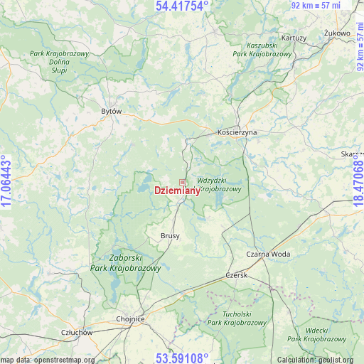
Dziemiany GPS coordinates[2]
54° 0' 22.896" North, 17° 46' 3.18" East
| Map corner | latitude | longitude |
|---|---|---|
| Upper-left | 54.41754°, | 17.06443° |
| Center: | 54.00636°, | 17.76755° |
| Lower-right: | 53.59108°, | 18.47068° |
| Map W x H: | 91.9×91.9 km | = 57.1×57.1mi |
| max Lat: | 54.83135° ⇑5.8% North |
| Dziemiany: | 54.00636° |
| min Lat: | ⇓94.2% South 49.21328° |
| min Long | Dziemiany | max Long |
| 14.20249° | 17.76755° | 24.03723° |
| W 22.4%⇐ | ⇒77.6% E |
Elevation
Elevation of Dziemiany is 163 m = 535 ft, and this is 28.4 m = 93 ft below average elevation for this country.
| Max E: |
974 m = 3196 ft | 53.3% |
| Avg. | 191.4 m = 628 ft | |
| Dziemiany | 163 m = 535 ft | |
Min E: |
-3 m = -10 ft | 46.7% |
See also: Poland elevation on elevation.city.
Geographical zone
Dziemiany is located in North temperate zone (between Tropic of Cancer and the Arctic Circle). Distance of this North polar circle is 1396.2 km =867.6 mi to North.| Distance of | km | miles | from Dziemiany |
|---|---|---|---|
| North Pole | 4002.1 | 2486.8 | to North |
| Arctic Circle | 1396.2 | 867.6 | to North |
| Tropic Cancer | 3399 | 2112 | to South |
| Equator | 6004.9 | 3731.3 | to South |


Nearby cities:
15 places around Dziemiany: (largest is in red/bold)
• Brusy
13.9 km =8.6 mi,  193°
193°
• Bytów
25.6 km =15.9 mi,  315°
315°
• Czarna Woda
28.2 km =17.5 mi,  129°
129°
• Czersk
27.1 km =16.8 mi,  149°
149°
• Grabowo Kościerskie
30.6 km =19 mi,  53°
53°
• Kalisz Pomorski
4.6 km =2.9 mi,  25°
25°
• Karsin
14.9 km =9.3 mi,  137°
137°
• Kościerzyna
19 km =11.8 mi, 47°
• Lipnica
23.6 km =14.7 mi,  267°
267°
• Lipusz
10.3 km =6.4 mi,  6°
6°
• Parchowo
23.2 km =14.4 mi,  343°
343°
• Stara Kiszewa
26.3 km =16.3 mi,  93°
93°
• Studzienice
15.8 km =9.8 mi,  307°
307°
• Stężyca
25.4 km =15.8 mi, 28°
• Sulęczyno
25.2 km =15.7 mi,  0°
0°
Sources, notices
• [Note1] Compared only with cities in Poland existing in our database
• [Src1] Map data: © OpenStreetMap contributors (CC-BY-SA)
• [Src2] Other city data from geonames.org with taken over terms of usage.
• [Src3] Geographical zone / Annual Mean Temperature by Robert A. Rohde @ Wikipedia
