Kalisz Pomorski geodata
Kalisz Pomorski (Pomerania) is a populated place; located in Poland in Europe/Warsaw (GMT+2) time zone. With population of 900 people, there are 2674 cities with bigger population in this country. Compared to other cities in Poland, 94.7% of cities are located further ↓South; 77.2% of cities are located further →East and 59.9% of cities have higher elevation than Kalisz Pomorski. Note1


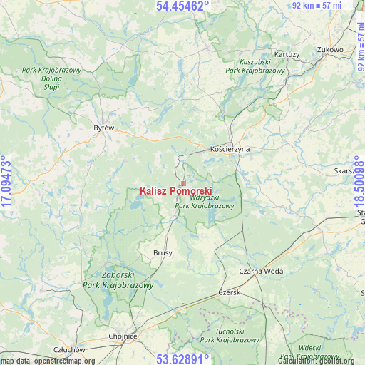
Kalisz Pomorski GPS coordinates[2]
54° 2' 37.752" North, 17° 47' 52.26" East
| Map corner | latitude | longitude |
|---|---|---|
| Upper-left | 54.45462°, | 17.09473° |
| Center: | 54.04382°, | 17.79785° |
| Lower-right: | 53.62891°, | 18.50098° |
| Map W x H: | 91.8×91.8 km | = 57×57mi |
| max Lat: | 54.83135° ⇑5.3% North |
| Kalisz Pomorski: | 54.04382° |
| min Lat: | ⇓94.7% South 49.21328° |
| min Long | Kalisz Pomorski | max Long |
| 14.20249° | 17.79785° | 24.03723° |
| W 22.8%⇐ | ⇒77.2% E |
Elevation
Elevation of Kalisz Pomorski is 147 m = 482 ft, and this is 44.4 m = 146 ft below average elevation for this country.
| Max E: |
974 m = 3196 ft | 59.9% |
| Avg. | 191.4 m = 628 ft | |
| Kalisz Pomorski | 147 m = 482 ft | |
Min E: |
-3 m = -10 ft | 40.1% |
See also: Poland elevation on elevation.city.
Geographical zone
Kalisz Pomorski is located in North temperate zone (between Tropic of Cancer and the Arctic Circle). Distance of this North polar circle is 1392.1 km =865 mi to North.| Distance of | km | miles | from Kalisz Pomorski |
|---|---|---|---|
| North Pole | 3998 | 2484.2 | to North |
| Arctic Circle | 1392.1 | 865 | to North |
| Tropic Cancer | 3403.2 | 2114.6 | to South |
| Equator | 6009.1 | 3733.9 | to South |


Nearby cities:
15 places around Kalisz Pomorski: (largest is in red/bold)
• Brusy
18.5 km =11.5 mi,  196°
196°
• Bytów
24.4 km =15.2 mi,  305°
305°
• Dziemiany
4.6 km =2.9 mi,  205°
205°
• Grabowo Kościerskie
26.6 km =16.5 mi,  58°
58°
• Karsin
17.1 km =10.6 mi,  152°
152°
• Kościerzyna
14.8 km =9.2 mi,  53°
53°
• Liniewo
28.2 km =17.5 mi,  82°
82°
• Lipnica
26.1 km =16.2 mi,  258°
258°
• Lipusz
6.1 km =3.8 mi,  351°
351°
• Nowa Karczma
28.2 km =17.5 mi,  69°
69°
• Parchowo
20 km =12.4 mi,  334°
334°
• Stara Kiszewa
25 km =15.5 mi,  103°
103°
• Studzienice
15.5 km =9.6 mi,  290°
290°
• Stężyca
20.8 km =12.9 mi,  29°
29°
• Sulęczyno
21.1 km =13.1 mi,  355°
355°
Sources, notices
• [Note1] Compared only with cities in Poland existing in our database
• [Src1] Map data: © OpenStreetMap contributors (CC-BY-SA)
• [Src2] Other city data from geonames.org with taken over terms of usage.
• [Src3] Geographical zone / Annual Mean Temperature by Robert A. Rohde @ Wikipedia
