Lipnica geodata
Lipnica (Pomerania) is a seat of a third-order administrative division; located in Poland in Europe/Warsaw (GMT+2) time zone. With population of 747 people, there are 2976 cities with bigger population in this country. Compared to other cities in Poland, 94.1% of cities are located further ↓South; 80.6% of cities are located further →East and 50.2% of cities have higher elevation than Lipnica. Note1


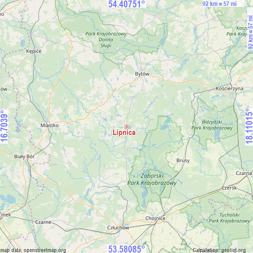
Lipnica GPS coordinates[2]
53° 59' 46.428" North, 17° 24' 25.272" East
| Map corner | latitude | longitude |
|---|---|---|
| Upper-left | 54.40751°, | 16.7039° |
| Center: | 53.99623°, | 17.40702° |
| Lower-right: | 53.58085°, | 18.11015° |
| Map W x H: | 91.9×91.9 km | = 57.1×57.1mi |
| max Lat: | 54.83135° ⇑5.9% North |
| Lipnica: | 53.99623° |
| min Lat: | ⇓94.1% South 49.21328° |
| min Long | Lipnica | max Long |
| 14.20249° | 17.40702° | 24.03723° |
| W 19.4%⇐ | ⇒80.6% E |
Elevation
Elevation of Lipnica is 171 m = 561 ft, and this is 20.4 m = 67 ft below average elevation for this country.
| Max E: |
974 m = 3196 ft | 50.2% |
| Avg. | 191.4 m = 628 ft | |
| Lipnica | 171 m = 561 ft | |
Min E: |
-3 m = -10 ft | 49.8% |
See also: Poland elevation on elevation.city.
Geographical zone
Lipnica is located in North temperate zone (between Tropic of Cancer and the Arctic Circle). Distance of this North polar circle is 1397.4 km =868.3 mi to North.| Distance of | km | miles | from Lipnica |
|---|---|---|---|
| North Pole | 4003.2 | 2487.5 | to North |
| Arctic Circle | 1397.4 | 868.3 | to North |
| Tropic Cancer | 3397.9 | 2111.4 | to South |
| Equator | 6003.8 | 3730.6 | to South |


Nearby cities:
15 places around Lipnica: (largest is in red/bold)
• Borzytuchom
22.8 km =14.2 mi,  353°
353°
• Brusy
23.8 km =14.8 mi,  121°
121°
• Bytów
20.2 km =12.6 mi,  15°
15°
• Dziemiany
23.6 km =14.7 mi,  87°
87°
• Kalisz Pomorski
26.1 km =16.2 mi,  78°
78°
• Koczała
24.6 km =15.3 mi,  245°
245°
• Konarzyny
19.3 km =12 mi,  185°
185°
• Kołczygłowy
29.3 km =18.2 mi,  337°
337°
• Lipusz
27.1 km =16.8 mi,  65°
65°
• Miastko
27.7 km =17.2 mi,  271°
271°
• Parchowo
28.9 km =18 mi,  36°
36°
• Przechlewo
24.2 km =15 mi,  204°
204°
• Studzienice
15.4 km =9.6 mi,  45°
45°
• Trzebielino
30.8 km =19.1 mi,  317°
317°
• Tuchomie
14 km =8.7 mi, 340°
Sources, notices
• [Note1] Compared only with cities in Poland existing in our database
• [Src1] Map data: © OpenStreetMap contributors (CC-BY-SA)
• [Src2] Other city data from geonames.org with taken over terms of usage.
• [Src3] Geographical zone / Annual Mean Temperature by Robert A. Rohde @ Wikipedia
