Łęczyca geodata
Łęczyca (Łódź Voivodeship) is a seat of a second-order administrative division; located in Poland in Europe/Warsaw (GMT+2) time zone. With population of 15,528 people, there are 321 cities with bigger population in this country. Compared to other cities in Poland, 66.7% of cities are located further ↓South; 56% of cities are located further →East and 74.5% of cities have higher elevation than Łęczyca. Note1


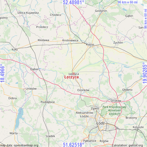
Łęczyca GPS coordinates[2]
52° 3' 34.524" North, 19° 11' 58.992" East
| Map corner | latitude | longitude |
|---|---|---|
| Upper-left | 52.48981°, | 18.4966° |
| Center: | 52.05959°, | 19.19972° |
| Lower-right: | 51.62518°, | 19.90285° |
| Map W x H: | 96.1×96.1 km | = 59.7×59.7mi |
| max Lat: | 54.83135° ⇑33.3% North |
| Łęczyca: | 52.05959° |
| min Lat: | ⇓66.7% South 49.21328° |
| min Long | Łęczyca | max Long |
| 14.20249° | 19.19972° | 24.03723° |
| W 44%⇐ | ⇒56% E |
Elevation
Elevation of Łęczyca is 112 m = 367 ft, and this is 79.4 m = 260 ft below average elevation for this country.
| Max E: |
974 m = 3196 ft | 74.5% |
| Avg. | 191.4 m = 628 ft | |
| Łęczyca | 112 m = 367 ft | |
Min E: |
-3 m = -10 ft | 25.5% |
See also: Poland elevation on elevation.city.
Geographical zone
Łęczyca is located in North temperate zone (between Tropic of Cancer and the Arctic Circle). Distance of this North polar circle is 1612.7 km =1002.1 mi to North.| Distance of | km | miles | from Łęczyca |
|---|---|---|---|
| North Pole | 4218.6 | 2621.3 | to North |
| Arctic Circle | 1612.7 | 1002.1 | to North |
| Tropic Cancer | 3182.6 | 1977.6 | to South |
| Equator | 5788.5 | 3596.8 | to South |


Nearby cities:
15 places around Łęczyca: (largest is in red/bold)
• Błonie
4.7 km =2.9 mi,  293°
293°
• Chodów
24.7 km =15.3 mi,  328°
328°
• Dalików
20.2 km =12.6 mi,  195°
195°
• Daszyna
10.7 km =6.6 mi,  353°
353°
• Grabów
15.4 km =9.6 mi,  299°
299°
• Góra Świętej Małgorzaty
8.2 km =5.1 mi,  91°
91°
• Krośniewice
21.9 km =13.6 mi, 354°
• Krzyżanów
22.3 km =13.9 mi,  51°
51°
• Kutno
22.1 km =13.7 mi,  30°
30°
• Ozorków
12.4 km =7.7 mi,  149°
149°
• Parzęczew
12.4 km =7.7 mi,  177°
177°
• Piątek
19.2 km =11.9 mi, 86°
• Wartkowice
16.4 km =10.2 mi,  235°
235°
• Witonia
11.9 km =7.4 mi,  35°
35°
• Świnice Warckie
19.4 km =12.1 mi,  263°
263°
Sources, notices
• [Note1] Compared only with cities in Poland existing in our database
• [Src1] Map data: © OpenStreetMap contributors (CC-BY-SA)
• [Src2] Other city data from geonames.org with taken over terms of usage.
• [Src3] Geographical zone / Annual Mean Temperature by Robert A. Rohde @ Wikipedia
