Daszyna geodata
Daszyna (Łódź Voivodeship) is a seat of a third-order administrative division; located in Poland in Europe/Warsaw (GMT+2) time zone. With population of 600 people, there are 3270 cities with bigger population in this country. Compared to other cities in Poland, 69% of cities are located further ↓South; 56.5% of cities are located further →East and 65.2% of cities have higher elevation than Daszyna. Note1


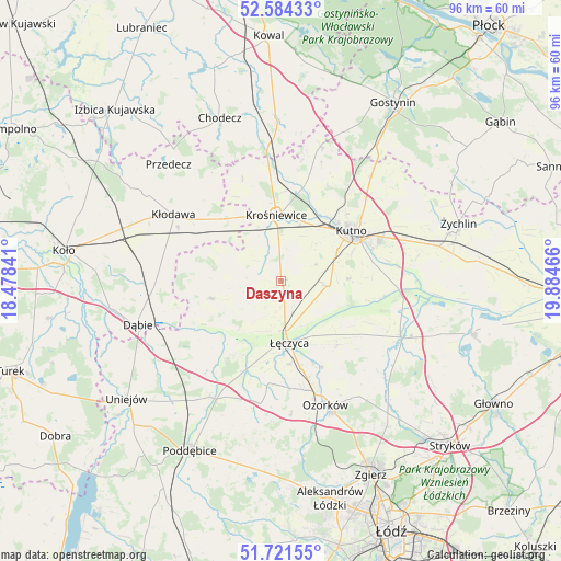
Daszyna GPS coordinates[2]
52° 9' 18.108" North, 19° 10' 53.508" East
| Map corner | latitude | longitude |
|---|---|---|
| Upper-left | 52.58433°, | 18.47841° |
| Center: | 52.15503°, | 19.18153° |
| Lower-right: | 51.72155°, | 19.88466° |
| Map W x H: | 95.9×95.9 km | = 59.6×59.6mi |
| max Lat: | 54.83135° ⇑31% North |
| Daszyna: | 52.15503° |
| min Lat: | ⇓69% South 49.21328° |
| min Long | Daszyna | max Long |
| 14.20249° | 19.18153° | 24.03723° |
| W 43.5%⇐ | ⇒56.5% E |
Elevation
Elevation of Daszyna is 132 m = 433 ft, and this is 59.4 m = 195 ft below average elevation for this country.
| Max E: |
974 m = 3196 ft | 65.2% |
| Avg. | 191.4 m = 628 ft | |
| Daszyna | 132 m = 433 ft | |
Min E: |
-3 m = -10 ft | 34.8% |
See also: Poland elevation on elevation.city.
Geographical zone
Daszyna is located in North temperate zone (between Tropic of Cancer and the Arctic Circle). Distance of this North polar circle is 1602.1 km =995.5 mi to North.| Distance of | km | miles | from Daszyna |
|---|---|---|---|
| North Pole | 4208 | 2614.7 | to North |
| Arctic Circle | 1602.1 | 995.5 | to North |
| Tropic Cancer | 3193.2 | 1984.2 | to South |
| Equator | 5799.1 | 3603.4 | to South |


Nearby cities:
15 places around Daszyna: (largest is in red/bold)
• Błonie
9.2 km =5.7 mi,  199°
199°
• Chodów
15.6 km =9.7 mi,  312°
312°
• Dąbrowice
18.6 km =11.6 mi,  339°
339°
• Grabów
12.6 km =7.8 mi,  255°
255°
• Góra Świętej Małgorzaty
14.4 km =8.9 mi,  139°
139°
• Krośniewice
11.2 km =7 mi,  356°
356°
• Krzyżanów
19 km =11.8 mi,  80°
80°
• Kutno
15 km =9.3 mi,  55°
55°
• Kłodawa
21.3 km =13.2 mi,  301°
301°
• Nowe Ostrowy
16.5 km =10.3 mi,  2°
2°
• Olszówka
22.1 km =13.7 mi,  280°
280°
• Ostrowy
16.6 km =10.3 mi, 356°
• Witonia
8.2 km =5.1 mi,  96°
96°
• Łęczyca
10.7 km =6.6 mi,  173°
173°
• Świnice Warckie
22 km =13.7 mi,  234°
234°
Sources, notices
• [Note1] Compared only with cities in Poland existing in our database
• [Src1] Map data: © OpenStreetMap contributors (CC-BY-SA)
• [Src2] Other city data from geonames.org with taken over terms of usage.
• [Src3] Geographical zone / Annual Mean Temperature by Robert A. Rohde @ Wikipedia
