Kołczygłowy geodata
Kołczygłowy (Pomerania) is a populated place; located in Poland in Europe/Warsaw (GMT+2) time zone. With population of 1,233 people, there are 2143 cities with bigger population in this country. Compared to other cities in Poland, 96.9% of cities are located further ↓South; 81.9% of cities are located further →East and 73.5% of cities have higher elevation than Kołczygłowy. Note1


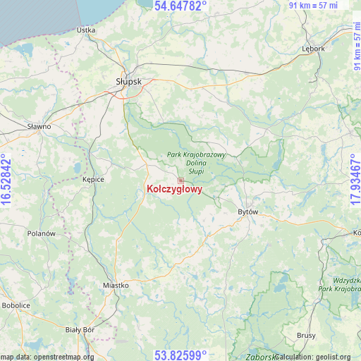
Kołczygłowy GPS coordinates[2]
54° 14' 20.22" North, 17° 13' 53.544" East
| Map corner | latitude | longitude |
|---|---|---|
| Upper-left | 54.64782°, | 16.52842° |
| Center: | 54.23895°, | 17.23154° |
| Lower-right: | 53.82599°, | 17.93467° |
| Map W x H: | 91.4×91.4 km | = 56.8×56.8mi |
| max Lat: | 54.83135° ⇑3.1% North |
| Kołczygłowy: | 54.23895° |
| min Lat: | ⇓96.9% South 49.21328° |
| min Long | Kołczygłowy | max Long |
| 14.20249° | 17.23154° | 24.03723° |
| W 18.1%⇐ | ⇒81.9% E |
Elevation
Elevation of Kołczygłowy is 114 m = 374 ft, and this is 77.4 m = 254 ft below average elevation for this country.
| Max E: |
974 m = 3196 ft | 73.5% |
| Avg. | 191.4 m = 628 ft | |
| Kołczygłowy | 114 m = 374 ft | |
Min E: |
-3 m = -10 ft | 26.5% |
See also: Poland elevation on elevation.city.
Geographical zone
Kołczygłowy is located in North temperate zone (between Tropic of Cancer and the Arctic Circle). Distance of this North polar circle is 1370.4 km =851.5 mi to North.| Distance of | km | miles | from Kołczygłowy |
|---|---|---|---|
| North Pole | 3976.3 | 2470.8 | to North |
| Arctic Circle | 1370.4 | 851.5 | to North |
| Tropic Cancer | 3424.9 | 2128.1 | to South |
| Equator | 6030.8 | 3747.4 | to South |


Nearby cities:
15 places around Kołczygłowy: (largest is in red/bold)
• Barcino
18 km =11.2 mi,  283°
283°
• Borzytuchom
9.9 km =6.2 mi,  115°
115°
• Bytów
18.6 km =11.6 mi,  114°
114°
• Czarna Dąbrówka
25.2 km =15.7 mi,  58°
58°
• Damnica
29.2 km =18.1 mi,  5°
5°
• Dębnica Kaszubska
16.2 km =10.1 mi,  343°
343°
• Kobylnica
27 km =16.8 mi,  325°
325°
• Kępice
22.2 km =13.8 mi,  270°
270°
• Lipnica
29.3 km =18.2 mi,  157°
157°
• Parchowo
28.6 km =17.8 mi,  97°
97°
• Studzienice
27.7 km =17.2 mi,  125°
125°
• Słupsk
28.3 km =17.6 mi, 332°
• Trzebielino
10.3 km =6.4 mi,  245°
245°
• Tuchomie
15.4 km =9.6 mi,  153°
153°
• Łupawa
23.2 km =14.4 mi,  30°
30°
Sources, notices
• [Note1] Compared only with cities in Poland existing in our database
• [Src1] Map data: © OpenStreetMap contributors (CC-BY-SA)
• [Src2] Other city data from geonames.org with taken over terms of usage.
• [Src3] Geographical zone / Annual Mean Temperature by Robert A. Rohde @ Wikipedia
