Jastarnia geodata
Jastarnia (Pomerania) is a seat of a third-order administrative division; located in Poland in Europe/Warsaw (GMT+2) time zone. With population of 3,925 people, there are 831 cities with bigger population in this country. Compared to other cities in Poland, 99.6% of cities are located further ↓South; 65.3% of cities are located further →East and 96.6% of cities have higher elevation than Jastarnia. Note1


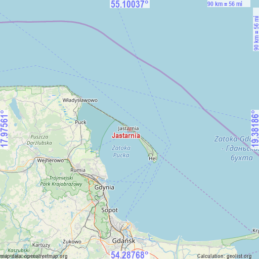
Jastarnia GPS coordinates[2]
54° 41' 45.816" North, 18° 40' 43.428" East
| Map corner | latitude | longitude |
|---|---|---|
| Upper-left | 55.10037°, | 17.97561° |
| Center: | 54.69606°, | 18.67873° |
| Lower-right: | 54.28768°, | 19.38186° |
| Map W x H: | 90.4×90.4 km | = 56.2×56.2mi |
| max Lat: | 54.83135° ⇑0.4% North |
| Jastarnia: | 54.69606° |
| min Lat: | ⇓99.6% South 49.21328° |
| min Long | Jastarnia | max Long |
| 14.20249° | 18.67873° | 24.03723° |
| W 34.7%⇐ | ⇒65.3% E |
Elevation
Elevation of Jastarnia is 26 m = 85 ft, and this is 165.4 m = 543 ft below average elevation for this country.
| Max E: |
974 m = 3196 ft | 96.6% |
| Avg. | 191.4 m = 628 ft | |
| Jastarnia | 26 m = 85 ft | |
Min E: |
-3 m = -10 ft | 3.4% |
See also: Poland elevation on elevation.city.
Geographical zone
Jastarnia is located in North temperate zone (between Tropic of Cancer and the Arctic Circle). Distance of this North polar circle is 1319.5 km =819.9 mi to North.| Distance of | km | miles | from Jastarnia |
|---|---|---|---|
| North Pole | 3925.4 | 2439.1 | to North |
| Arctic Circle | 1319.5 | 819.9 | to North |
| Tropic Cancer | 3475.7 | 2159.7 | to South |
| Equator | 6081.6 | 3778.9 | to South |


Nearby cities:
15 places around Jastarnia: (largest is in red/bold)
• Dębogórze
18.4 km =11.4 mi,  230°
230°
• Gdynia
21.9 km =13.6 mi,  205°
205°
• Gnieżdżewo
20 km =12.4 mi,  286°
286°
• Hel
12.6 km =7.8 mi,  141°
141°
• Kosakowo
17.2 km =10.7 mi, 226°
• Mosty
15 km =9.3 mi, 231°
• Mrzezino
16.7 km =10.4 mi,  253°
253°
• Pierwoszyno
15.9 km =9.9 mi, 226°
• Pogórze
19.4 km =12.1 mi,  220°
220°
• Puck
17.5 km =10.9 mi,  277°
277°
• Rekowo Dolne
21.6 km =13.4 mi, 250°
• Rewa
13 km =8.1 mi,  237°
237°
• Swarzewo
19.5 km =12.1 mi, 292°
• Władysławowo
20.7 km =12.9 mi,  300°
300°
• Żelistrzewo
16.9 km =10.5 mi,  263°
263°
Sources, notices
• [Note1] Compared only with cities in Poland existing in our database
• [Src1] Map data: © OpenStreetMap contributors (CC-BY-SA)
• [Src2] Other city data from geonames.org with taken over terms of usage.
• [Src3] Geographical zone / Annual Mean Temperature by Robert A. Rohde @ Wikipedia
