Hel geodata
Hel (Pomerania) is a seat of a third-order administrative division; located in Poland in Europe/Warsaw (GMT+2) time zone. With population of 4,136 people, there are 788 cities with bigger population in this country. Compared to other cities in Poland, 99.3% of cities are located further ↓South; 63.3% of cities are located further →East and 99.8% of cities have higher elevation than Hel. Note1


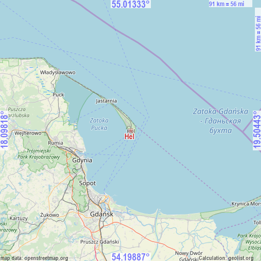
Hel GPS coordinates[2]
54° 36' 29.304" North, 18° 48' 4.68" East
| Map corner | latitude | longitude |
|---|---|---|
| Upper-left | 55.01333°, | 18.09818° |
| Center: | 54.60814°, | 18.8013° |
| Lower-right: | 54.19887°, | 19.50443° |
| Map W x H: | 90.6×90.6 km | = 56.3×56.3mi |
| max Lat: | 54.83135° ⇑0.7% North |
| Hel: | 54.60814° |
| min Lat: | ⇓99.3% South 49.21328° |
| min Long | Hel | max Long |
| 14.20249° | 18.8013° | 24.03723° |
| W 36.7%⇐ | ⇒63.3% E |
Elevation
Elevation of Hel is 1 m = 3 ft, and this is 190.4 m = 625 ft below average elevation for this country.
| Max E: |
974 m = 3196 ft | 99.8% |
| Avg. | 191.4 m = 628 ft | |
| Hel | 1 m = 3 ft | |
Min E: |
-3 m = -10 ft | 0.2% |
See also: Poland elevation on elevation.city.
Geographical zone
Hel is located in North temperate zone (between Tropic of Cancer and the Arctic Circle). Distance of this North polar circle is 1329.3 km =826 mi to North.| Distance of | km | miles | from Hel |
|---|---|---|---|
| North Pole | 3935.2 | 2445.2 | to North |
| Arctic Circle | 1329.3 | 826 | to North |
| Tropic Cancer | 3465.9 | 2153.6 | to South |
| Equator | 6071.9 | 3772.9 | to South |


Nearby cities:
15 places around Hel: (largest is in red/bold)
• Dębogórze
22.2 km =13.8 mi,  265°
265°
• Gdynia
20 km =12.4 mi,  240°
240°
• Jastarnia
12.6 km =7.8 mi,  321°
321°
• Kosakowo
20.5 km =12.7 mi,  264°
264°
• Mosty
19.6 km =12.2 mi, 271°
• Mrzezino
24.4 km =15.2 mi,  281°
281°
• Pierwoszyno
19.4 km =12.1 mi, 266°
• Pogórze
21.1 km =13.1 mi, 256°
• Puck
28.1 km =17.5 mi,  295°
295°
• Rekowo Dolne
28.3 km =17.6 mi, 275°
• Rewa
19 km =11.8 mi, 278°
• Rumia
26.9 km =16.7 mi, 261°
• Sopot
24.2 km =15 mi,  220°
220°
• Wielki Kack
25.5 km =15.8 mi,  232°
232°
• Żelistrzewo
25.9 km =16.1 mi,  287°
287°
Sources, notices
• [Note1] Compared only with cities in Poland existing in our database
• [Src1] Map data: © OpenStreetMap contributors (CC-BY-SA)
• [Src2] Other city data from geonames.org with taken over terms of usage.
• [Src3] Geographical zone / Annual Mean Temperature by Robert A. Rohde @ Wikipedia
