Górażdże geodata
Górażdże (Opole Voivodeship) is a populated place; located in Poland in Europe/Warsaw (GMT+2) time zone. With population of 1,073 people, there are 2385 cities with bigger population in this country. Compared to other cities in Poland, 66.7% of cities are located further ↑North; 75.1% of cities are located further →East and 50.8% of cities have higher elevation than Górażdże. Note1


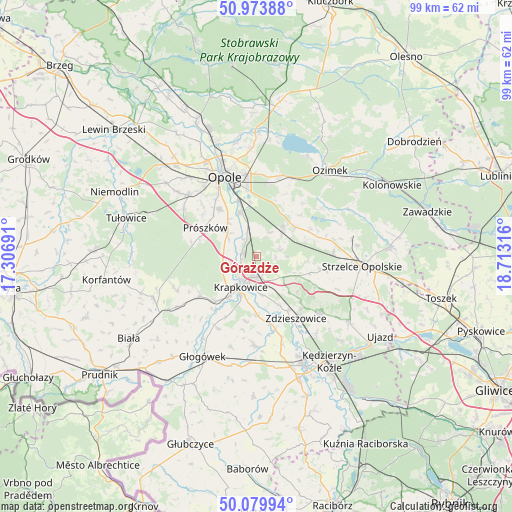
Górażdże GPS coordinates[2]
50° 31' 44.508" North, 18° 0' 36.108" East
| Map corner | latitude | longitude |
|---|---|---|
| Upper-left | 50.97388°, | 17.30691° |
| Center: | 50.52903°, | 18.01003° |
| Lower-right: | 50.07994°, | 18.71316° |
| Map W x H: | 99.4×99.4 km | = 61.8×61.8mi |
| max Lat: | 54.83135° ⇑66.7% North |
| Górażdże: | 50.52903° |
| min Lat: | ⇓33.3% South 49.21328° |
| min Long | Górażdże | max Long |
| 14.20249° | 18.01003° | 24.03723° |
| W 24.9%⇐ | ⇒75.1% E |
Elevation
Elevation of Górażdże is 170 m = 558 ft, and this is 21.4 m = 70 ft below average elevation for this country.
| Max E: |
974 m = 3196 ft | 50.8% |
| Avg. | 191.4 m = 628 ft | |
| Górażdże | 170 m = 558 ft | |
Min E: |
-3 m = -10 ft | 49.2% |
See also: Poland elevation on elevation.city.
Geographical zone
Górażdże is located in North temperate zone (between Tropic of Cancer and the Arctic Circle). Distance of this North polar circle is 1782.9 km =1107.8 mi to North.| Distance of | km | miles | from Górażdże |
|---|---|---|---|
| North Pole | 4388.8 | 2727.1 | to North |
| Arctic Circle | 1782.9 | 1107.8 | to North |
| Tropic Cancer | 3012.4 | 1871.8 | to South |
| Equator | 5618.3 | 3491 | to South |


Nearby cities:
15 places around Górażdże: (largest is in red/bold)
• Chrząstowice
15.9 km =9.9 mi,  16°
16°
• Dobra
11.2 km =7 mi,  220°
220°
• Gogolin
4.2 km =2.6 mi,  170°
170°
• Izbicko
11.3 km =7 mi,  65°
65°
• Kosorowice
5.4 km =3.4 mi,  28°
28°
• Krapkowice
6.8 km =4.2 mi,  207°
207°
• Kórnica
15.7 km =9.8 mi, 208°
• Kąty Opolskie
4.2 km =2.6 mi,  323°
323°
• Leśnica
16.6 km =10.3 mi,  131°
131°
• Nakło
9.5 km =5.9 mi,  53°
53°
• Prószków
11.1 km =6.9 mi,  298°
298°
• Rozwadza
12.2 km =7.6 mi,  148°
148°
• Strzeleczki
13.2 km =8.2 mi,  235°
235°
• Tarnów Opolski
7.4 km =4.6 mi,  44°
44°
• Zdzieszowice
14.1 km =8.8 mi, 145°
Sources, notices
• [Note1] Compared only with cities in Poland existing in our database
• [Src1] Map data: © OpenStreetMap contributors (CC-BY-SA)
• [Src2] Other city data from geonames.org with taken over terms of usage.
• [Src3] Geographical zone / Annual Mean Temperature by Robert A. Rohde @ Wikipedia
