Prószków geodata
Prószków (Opole Voivodeship) is a populated place; located in Poland in Europe/Warsaw (GMT+2) time zone. With population of 2,691 people, there are 1173 cities with bigger population in this country. Compared to other cities in Poland, 65.7% of cities are located further ↑North; 76.4% of cities are located further →East and 54.6% of cities have lower elevation than Prószków. Note1


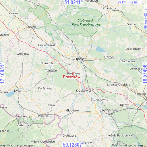
Prószków GPS coordinates[2]
50° 34' 36.12" North, 17° 52' 17.148" East
| Map corner | latitude | longitude |
|---|---|---|
| Upper-left | 51.0211°, | 17.16831° |
| Center: | 50.5767°, | 17.87143° |
| Lower-right: | 50.12807°, | 18.57456° |
| Map W x H: | 99.3×99.3 km | = 61.7×61.7mi |
| max Lat: | 54.83135° ⇑65.7% North |
| Prószków: | 50.5767° |
| min Lat: | ⇓34.3% South 49.21328° |
| min Long | Prószków | max Long |
| 14.20249° | 17.87143° | 24.03723° |
| W 23.6%⇐ | ⇒76.4% E |
Elevation
Elevation of Prószków is 184 m = 604 ft, and this is 7.4 m = 24 ft below average elevation for this country.
| Max E: |
974 m = 3196 ft | 45.4% |
| Avg. | 191.4 m = 628 ft | |
| Prószków | 184 m = 604 ft | |
Min E: |
-3 m = -10 ft | 54.6% |
See also: Poland elevation on elevation.city.
Geographical zone
Prószków is located in North temperate zone (between Tropic of Cancer and the Arctic Circle). Distance of this North polar circle is 1777.6 km =1104.5 mi to North.| Distance of | km | miles | from Prószków |
|---|---|---|---|
| North Pole | 4383.5 | 2723.8 | to North |
| Arctic Circle | 1777.6 | 1104.5 | to North |
| Tropic Cancer | 3017.7 | 1875.1 | to South |
| Equator | 5623.6 | 3494.3 | to South |


Nearby cities:
15 places around Prószków: (largest is in red/bold)
• Chmielowice
8.1 km =5 mi,  357°
357°
• Chrościna
10.6 km =6.6 mi,  339°
339°
• Dobra
14.1 km =8.8 mi,  169°
169°
• Dąbrowa
14.7 km =9.1 mi,  324°
324°
• Gogolin
14.1 km =8.8 mi,  131°
131°
• Górażdże
11.1 km =6.9 mi,  118°
118°
• Karczów
15.4 km =9.6 mi, 336°
• Komprachcice
7.4 km =4.6 mi,  334°
334°
• Kosorowice
12.4 km =7.7 mi,  92°
92°
• Krapkowice
13.1 km =8.1 mi,  149°
149°
• Kujawy
15.5 km =9.6 mi,  197°
197°
• Kąty Opolskie
7.5 km =4.7 mi,  104°
104°
• Opole
11.3 km =7 mi,  19°
19°
• Strzeleczki
12.8 km =8 mi,  184°
184°
• Tarnów Opolski
15 km =9.3 mi, 90°
Sources, notices
• [Note1] Compared only with cities in Poland existing in our database
• [Src1] Map data: © OpenStreetMap contributors (CC-BY-SA)
• [Src2] Other city data from geonames.org with taken over terms of usage.
• [Src3] Geographical zone / Annual Mean Temperature by Robert A. Rohde @ Wikipedia
