Krapkowice geodata
Krapkowice (Opole Voivodeship) is a seat of a second-order administrative division; located in Poland in Europe/Warsaw (GMT+2) time zone. With population of 18,275 people, there are 269 cities with bigger population in this country. Compared to other cities in Poland, 67.7% of cities are located further ↑North; 75.6% of cities are located further →East and 51.5% of cities have lower elevation than Krapkowice. Note1
Administrative division(s):
- Level 1: Opole Voivodeship
- Level 2: Powiat krapkowicki
- Level 3: Krapkowice


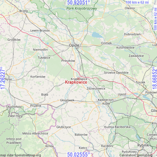
Krapkowice GPS coordinates[2]
50° 28' 30.54" North, 17° 57' 55.404" East
| Map corner | latitude | longitude |
|---|---|---|
| Upper-left | 50.92051°, | 17.26227° |
| Center: | 50.47515°, | 17.96539° |
| Lower-right: | 50.02555°, | 18.66852° |
| Map W x H: | 99.5×99.5 km | = 61.8×61.8mi |
| max Lat: | 54.83135° ⇑67.7% North |
| Krapkowice: | 50.47515° |
| min Lat: | ⇓32.3% South 49.21328° |
| min Long | Krapkowice | max Long |
| 14.20249° | 17.96539° | 24.03723° |
| W 24.4%⇐ | ⇒75.6% E |
Elevation
Elevation of Krapkowice is 176 m = 577 ft, and this is 15.4 m = 51 ft below average elevation for this country.
| Max E: |
974 m = 3196 ft | 48.5% |
| Avg. | 191.4 m = 628 ft | |
| Krapkowice | 176 m = 577 ft | |
Min E: |
-3 m = -10 ft | 51.5% |
See also: Poland elevation on elevation.city.
Geographical zone
Krapkowice is located in North temperate zone (between Tropic of Cancer and the Arctic Circle). Distance of this North polar circle is 1788.9 km =1111.6 mi to North.| Distance of | km | miles | from Krapkowice |
|---|---|---|---|
| North Pole | 4394.8 | 2730.8 | to North |
| Arctic Circle | 1788.9 | 1111.6 | to North |
| Tropic Cancer | 3006.4 | 1868.1 | to South |
| Equator | 5612.3 | 3487.3 | to South |


Nearby cities:
15 places around Krapkowice: (largest is in red/bold)
• Dobieszowice
13.2 km =8.2 mi,  161°
161°
• Dobra
4.9 km =3 mi,  237°
237°
• Gogolin
4.3 km =2.7 mi,  63°
63°
• Górażdże
6.8 km =4.2 mi,  27°
27°
• Kosorowice
12.1 km =7.5 mi, 28°
• Kujawy
11.8 km =7.3 mi,  252°
252°
• Kórnica
9 km =5.6 mi,  208°
208°
• Kąty Opolskie
9.4 km =5.8 mi,  3°
3°
• Poborszów
13.9 km =8.6 mi,  143°
143°
• Prószków
13.1 km =8.1 mi,  329°
329°
• Rozkochów
11.8 km =7.3 mi,  188°
188°
• Rozwadza
10.5 km =6.5 mi,  115°
115°
• Strzeleczki
7.8 km =4.8 mi,  259°
259°
• Walce
11.7 km =7.3 mi,  166°
166°
• Zdzieszowice
12.5 km =7.8 mi, 116°
Sources, notices
• [Note1] Compared only with cities in Poland existing in our database
• [Src1] Map data: © OpenStreetMap contributors (CC-BY-SA)
• [Src2] Other city data from geonames.org with taken over terms of usage.
• [Src3] Geographical zone / Annual Mean Temperature by Robert A. Rohde @ Wikipedia
