Lelkowo geodata
Lelkowo (Warmia-Masuria) is a populated place; located in Poland in Europe/Warsaw (GMT+2) time zone. With population of 1,080 people, there are 2380 cities with bigger population in this country. Compared to other cities in Poland, 97.7% of cities are located further ↓South; 61.4% of cities are located further ←West and 73.5% of cities have higher elevation than Lelkowo. Note1


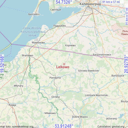
Lelkowo GPS coordinates[2]
54° 19' 28.488" North, 20° 13' 29.28" East
| Map corner | latitude | longitude |
|---|---|---|
| Upper-left | 54.7326°, | 19.52168° |
| Center: | 54.32458°, | 20.2248° |
| Lower-right: | 53.91248°, | 20.92793° |
| Map W x H: | 91.2×91.2 km | = 56.7×56.7mi |
| max Lat: | 54.83135° ⇑2.3% North |
| Lelkowo: | 54.32458° |
| min Lat: | ⇓97.7% South 49.21328° |
| min Long | Lelkowo | max Long |
| 14.20249° | 20.2248° | 24.03723° |
| W 61.4%⇐ | ⇒38.6% E |
Elevation
Elevation of Lelkowo is 114 m = 374 ft, and this is 77.4 m = 254 ft below average elevation for this country.
| Max E: |
974 m = 3196 ft | 73.5% |
| Avg. | 191.4 m = 628 ft | |
| Lelkowo | 114 m = 374 ft | |
Min E: |
-3 m = -10 ft | 26.5% |
See also: Poland elevation on elevation.city.
Geographical zone
Lelkowo is located in North temperate zone (between Tropic of Cancer and the Arctic Circle). Distance of this North polar circle is 1360.8 km =845.6 mi to North.| Distance of | km | miles | from Lelkowo |
|---|---|---|---|
| North Pole | 3966.7 | 2464.8 | to North |
| Arctic Circle | 1360.8 | 845.6 | to North |
| Tropic Cancer | 3434.4 | 2134 | to South |
| Equator | 6040.3 | 3753.3 | to South |


Nearby cities:
15 places around Lelkowo: (largest is in red/bold)
• Bartoszyce
38.7 km =24 mi,  101°
101°
• Braniewo
27 km =16.8 mi,  283°
283°
• Dobre Miasto
39.2 km =24.4 mi,  163°
163°
• Frombork
35.5 km =22.1 mi, 275°
• Górowo Iławeckie
17.7 km =11 mi, 104°
• Janikowo
19.1 km =11.9 mi,  126°
126°
• Kamiennik Wielki
46.8 km =29.1 mi,  250°
250°
• Lidzbark Warmiński
31.9 km =19.8 mi, 133°
• Lubomino
28.7 km =17.8 mi,  178°
178°
• Miłakowo
36.5 km =22.7 mi,  195°
195°
• Młynary
36.1 km =22.4 mi,  244°
244°
• Orneta
24.1 km =15 mi,  194°
194°
• Pieniężno
11.6 km =7.2 mi,  212°
212°
• Tolkmicko
45.3 km =28.1 mi,  269°
269°
• Świątki
44.2 km =27.5 mi, 178°
Sources, notices
• [Note1] Compared only with cities in Poland existing in our database
• [Src1] Map data: © OpenStreetMap contributors (CC-BY-SA)
• [Src2] Other city data from geonames.org with taken over terms of usage.
• [Src3] Geographical zone / Annual Mean Temperature by Robert A. Rohde @ Wikipedia
