Pieniężno geodata
Pieniężno (Warmia-Masuria) is a seat of a third-order administrative division; located in Poland in Europe/Warsaw (GMT+2) time zone. With population of 2,845 people, there are 1105 cities with bigger population in this country. Compared to other cities in Poland, 96.8% of cities are located further ↓South; 60.4% of cities are located further ←West and 89.6% of cities have higher elevation than Pieniężno. Note1


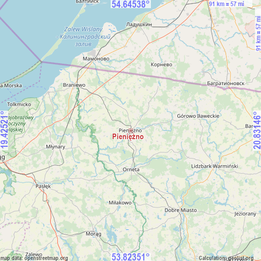
Pieniężno GPS coordinates[2]
54° 14' 11.364" North, 20° 7' 41.988" East
| Map corner | latitude | longitude |
|---|---|---|
| Upper-left | 54.64538°, | 19.42521° |
| Center: | 54.23649°, | 20.12833° |
| Lower-right: | 53.82351°, | 20.83146° |
| Map W x H: | 91.4×91.4 km | = 56.8×56.8mi |
| max Lat: | 54.83135° ⇑3.2% North |
| Pieniężno: | 54.23649° |
| min Lat: | ⇓96.8% South 49.21328° |
| min Long | Pieniężno | max Long |
| 14.20249° | 20.12833° | 24.03723° |
| W 60.4%⇐ | ⇒39.6% E |
Elevation
Elevation of Pieniężno is 77 m = 253 ft, and this is 114.4 m = 375 ft below average elevation for this country.
| Max E: |
974 m = 3196 ft | 89.6% |
| Avg. | 191.4 m = 628 ft | |
| Pieniężno | 77 m = 253 ft | |
Min E: |
-3 m = -10 ft | 10.4% |
See also: Poland elevation on elevation.city.
Geographical zone
Pieniężno is located in North temperate zone (between Tropic of Cancer and the Arctic Circle). Distance of this North polar circle is 1370.6 km =851.7 mi to North.| Distance of | km | miles | from Pieniężno |
|---|---|---|---|
| North Pole | 3976.5 | 2470.9 | to North |
| Arctic Circle | 1370.6 | 851.7 | to North |
| Tropic Cancer | 3424.6 | 2127.9 | to South |
| Equator | 6030.5 | 3747.2 | to South |


Nearby cities:
15 places around Pieniężno: (largest is in red/bold)
• Braniewo
25.6 km =15.9 mi,  308°
308°
• Dobre Miasto
32.9 km =20.4 mi,  147°
147°
• Frombork
32 km =19.9 mi,  294°
294°
• Górowo Iławeckie
24 km =14.9 mi,  76°
76°
• Janikowo
21.7 km =13.5 mi,  94°
94°
• Kamiennik Wielki
38.3 km =23.8 mi,  261°
261°
• Lelkowo
11.6 km =7.2 mi,  32°
32°
• Lidzbark Warmiński
31.8 km =19.8 mi,  112°
112°
• Lubomino
20.2 km =12.6 mi,  158°
158°
• Miłakowo
25.5 km =15.8 mi,  188°
188°
• Morąg
37.9 km =23.5 mi,  200°
200°
• Młynary
27 km =16.8 mi, 258°
• Orneta
13.5 km =8.4 mi,  178°
178°
• Pasłęk
36.2 km =22.5 mi,  237°
237°
• Świątki
35.2 km =21.9 mi,  167°
167°
Sources, notices
• [Note1] Compared only with cities in Poland existing in our database
• [Src1] Map data: © OpenStreetMap contributors (CC-BY-SA)
• [Src2] Other city data from geonames.org with taken over terms of usage.
• [Src3] Geographical zone / Annual Mean Temperature by Robert A. Rohde @ Wikipedia
