Kędzierzyn-Koźle geodata
Kędzierzyn-Koźle (Opole Voivodeship) is a seat of a second-order administrative division; located in Poland in Europe/Warsaw (GMT+2) time zone. With population of 65,636 people, there are 77 cities with bigger population in this country. Compared to other cities in Poland, 70.8% of cities are located further ↑North; 72.1% of cities are located further →East and 53.8% of cities have lower elevation than Kędzierzyn-Koźle. Note1
Administrative division(s):
- Level 1: Opole Voivodeship
- Level 2: Powiat kędzierzyńsko-kozielski
- Level 3: Kędzierzyn-Koźle


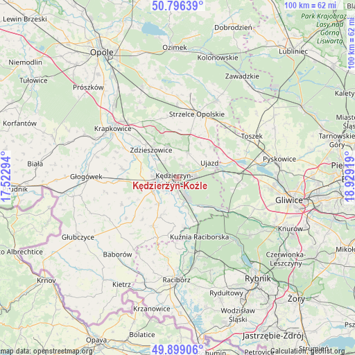
Kędzierzyn-Koźle GPS coordinates[2]
50° 20' 59.424" North, 18° 13' 33.816" East
| Map corner | latitude | longitude |
|---|---|---|
| Upper-left | 50.79639°, | 17.52294° |
| Center: | 50.34984°, | 18.22606° |
| Lower-right: | 49.89906°, | 18.92919° |
| Map W x H: | 99.8×99.8 km | = 62×62mi |
| max Lat: | 54.83135° ⇑70.8% North |
| Kędzierzyn-Koźle: | 50.34984° |
| min Lat: | ⇓29.2% South 49.21328° |
| min Long | Kędzierzyn-Ko� | max Long |
| 14.20249° | 18.22606° | 24.03723° |
| W 27.9%⇐ | ⇒72.1% E |
Elevation
Elevation of Kędzierzyn-Koźle is 182 m = 597 ft, and this is 9.4 m = 31 ft below average elevation for this country.
| Max E: |
974 m = 3196 ft | 46.2% |
| Avg. | 191.4 m = 628 ft | |
| Kędzierzyn-Koźle | 182 m = 597 ft | |
Min E: |
-3 m = -10 ft | 53.8% |
See also: Kędzierzyn-Koźle elevation on elevation.city.
Geographical zone
Kędzierzyn-Koźle is located in North temperate zone (between Tropic of Cancer and the Arctic Circle). Distance of this North polar circle is 1802.8 km =1120.2 mi to North.| Distance of | km | miles | from Kędzierzyn-Koźle |
|---|---|---|---|
| North Pole | 4408.7 | 2739.4 | to North |
| Arctic Circle | 1802.8 | 1120.2 | to North |
| Tropic Cancer | 2992.5 | 1859.5 | to South |
| Equator | 5598.4 | 3478.7 | to South |


Nearby cities:
15 places around Kędzierzyn-Koźle: (largest is in red/bold)
• Bierawa
7.7 km =4.8 mi,  171°
171°
• Cisek
7.7 km =4.8 mi,  193°
193°
• Długomiłowice
9.2 km =5.7 mi,  216°
216°
• Januszkowice
7.9 km =4.9 mi,  306°
306°
• Komorno
10.8 km =6.7 mi,  274°
274°
• Koźle
6.1 km =3.8 mi,  254°
254°
• Leśnica
9.4 km =5.8 mi,  342°
342°
• Lubieszów
10.3 km =6.4 mi,  164°
164°
• Poborszów
10.5 km =6.5 mi,  285°
285°
• Raszowa
6.4 km =4 mi,  326°
326°
• Reńska Wieś
8 km =5 mi,  241°
241°
• Sławięcice
7.2 km =4.5 mi,  69°
69°
• Ujazd
9.8 km =6.1 mi,  63°
63°
• Większyce
8.9 km =5.5 mi,  260°
260°
• Zdzieszowice
11.1 km =6.9 mi,  318°
318°
Sources, notices
• [Note1] Compared only with cities in Poland existing in our database
• [Src1] Map data: © OpenStreetMap contributors (CC-BY-SA)
• [Src2] Other city data from geonames.org with taken over terms of usage.
• [Src3] Geographical zone / Annual Mean Temperature by Robert A. Rohde @ Wikipedia
