Rokietnica geodata
Rokietnica (Greater Poland) is a seat of a third-order administrative division; located in Poland in Europe/Warsaw (GMT+2) time zone. With population of 1,900 people, there are 1552 cities with bigger population in this country. Compared to other cities in Poland, 76.7% of cities are located further ↓South; 87.6% of cities are located further →East and 85.2% of cities have higher elevation than Rokietnica. Note1


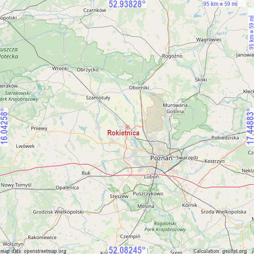
Rokietnica GPS coordinates[2]
52° 30' 44.82" North, 16° 44' 44.52" East
| Map corner | latitude | longitude |
|---|---|---|
| Upper-left | 52.93828°, | 16.04258° |
| Center: | 52.51245°, | 16.7457° |
| Lower-right: | 52.08245°, | 17.44883° |
| Map W x H: | 95.2×95.2 km | = 59.2×59.2mi |
| max Lat: | 54.83135° ⇑23.3% North |
| Rokietnica: | 52.51245° |
| min Lat: | ⇓76.7% South 49.21328° |
| min Long | Rokietnica | max Long |
| 14.20249° | 16.7457° | 24.03723° |
| W 12.4%⇐ | ⇒87.6% E |
Elevation
Elevation of Rokietnica is 89 m = 292 ft, and this is 102.4 m = 336 ft below average elevation for this country.
| Max E: |
974 m = 3196 ft | 85.2% |
| Avg. | 191.4 m = 628 ft | |
| Rokietnica | 89 m = 292 ft | |
Min E: |
-3 m = -10 ft | 14.8% |
See also: Poland elevation on elevation.city.
Geographical zone
Rokietnica is located in North temperate zone (between Tropic of Cancer and the Arctic Circle). Distance of this North polar circle is 1562.3 km =970.8 mi to North.| Distance of | km | miles | from Rokietnica |
|---|---|---|---|
| North Pole | 4168.2 | 2590 | to North |
| Arctic Circle | 1562.3 | 970.8 | to North |
| Tropic Cancer | 3232.9 | 2008.8 | to South |
| Equator | 5838.8 | 3628.1 | to South |


Nearby cities:
15 places around Rokietnica: (largest is in red/bold)
• Baranowo
9 km =5.6 mi,  162°
162°
• Czerwonak
16.8 km =10.4 mi,  108°
108°
• Dopiewo
17.9 km =11.1 mi,  195°
195°
• Kaźmierz
10.9 km =6.8 mi,  270°
270°
• Murowana Goślina
19.1 km =11.9 mi,  68°
68°
• Objezierze
10.3 km =6.4 mi,  6°
6°
• Oborniki
15.7 km =9.8 mi,  17°
17°
• Pamiątkowo
6.3 km =3.9 mi,  316°
316°
• Plewiska
16.7 km =10.4 mi, 164°
• Poznań
17.1 km =10.6 mi,  133°
133°
• Suchy Las
9.9 km =6.2 mi,  116°
116°
• Szamotuły
15.8 km =9.8 mi,  314°
314°
• Tarnowo Podgórne
7.6 km =4.7 mi,  227°
227°
• Zakrzewo
13.3 km =8.3 mi,  186°
186°
• Złotniki
7 km =4.3 mi, 106°
Sources, notices
• [Note1] Compared only with cities in Poland existing in our database
• [Src1] Map data: © OpenStreetMap contributors (CC-BY-SA)
• [Src2] Other city data from geonames.org with taken over terms of usage.
• [Src3] Geographical zone / Annual Mean Temperature by Robert A. Rohde @ Wikipedia
