Kraszewice geodata
Kraszewice (Greater Poland) is a seat of a third-order administrative division; located in Poland in Europe/Warsaw (GMT+2) time zone. With population of 1,600 people, there are 1751 cities with bigger population in this country. Compared to other cities in Poland, 56.6% of cities are located further ↓South; 72.2% of cities are located further →East and 65.6% of cities have higher elevation than Kraszewice. Note1
Administrative division(s):
- Level 1: Greater Poland
- Level 2: Powiat ostrzeszowski
- Level 3: Kraszewice


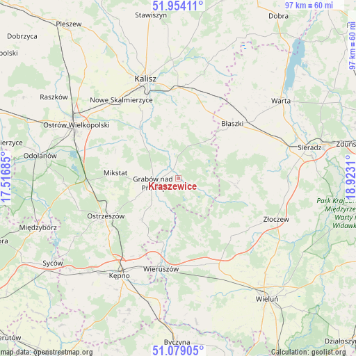
Kraszewice GPS coordinates[2]
51° 31' 7.248" North, 18° 13' 11.892" East
| Map corner | latitude | longitude |
|---|---|---|
| Upper-left | 51.95411°, | 17.51685° |
| Center: | 51.51868°, | 18.21997° |
| Lower-right: | 51.07905°, | 18.9231° |
| Map W x H: | 97.3×97.3 km | = 60.5×60.5mi |
| max Lat: | 54.83135° ⇑43.4% North |
| Kraszewice: | 51.51868° |
| min Lat: | ⇓56.6% South 49.21328° |
| min Long | Kraszewice | max Long |
| 14.20249° | 18.21997° | 24.03723° |
| W 27.8%⇐ | ⇒72.2% E |
Elevation
Elevation of Kraszewice is 131 m = 430 ft, and this is 60.4 m = 198 ft below average elevation for this country.
| Max E: |
974 m = 3196 ft | 65.6% |
| Avg. | 191.4 m = 628 ft | |
| Kraszewice | 131 m = 430 ft | |
Min E: |
-3 m = -10 ft | 34.4% |
See also: Poland elevation on elevation.city.
Geographical zone
Kraszewice is located in North temperate zone (between Tropic of Cancer and the Arctic Circle). Distance of this North polar circle is 1672.8 km =1039.4 mi to North.| Distance of | km | miles | from Kraszewice |
|---|---|---|---|
| North Pole | 4278.7 | 2658.7 | to North |
| Arctic Circle | 1672.8 | 1039.4 | to North |
| Tropic Cancer | 3122.4 | 1940.2 | to South |
| Equator | 5728.3 | 3559.4 | to South |


Nearby cities:
15 places around Kraszewice: (largest is in red/bold)
• Borysławice
20.7 km =12.9 mi,  43°
43°
• Brzeziny
8.9 km =5.5 mi,  15°
15°
• Brąszewice
16.1 km =10 mi,  97°
97°
• Błaszki
20.9 km =13 mi,  45°
45°
• Czajków
8 km =5 mi,  111°
111°
• Doruchów
15 km =9.3 mi,  221°
221°
• Galewice
19.5 km =12.1 mi,  172°
172°
• Godziesze Wielkie
14.4 km =8.9 mi,  346°
346°
• Grabów nad Prosną
7.1 km =4.4 mi,  258°
258°
• Klonowa
17.6 km =10.9 mi,  128°
128°
• Mikstat
17.1 km =10.6 mi,  275°
275°
• Osiek
16.9 km =10.5 mi,  184°
184°
• Psary
21.1 km =13.1 mi,  317°
317°
• Sieroszewice
21.4 km =13.3 mi,  306°
306°
• Szczytniki
20.4 km =12.7 mi, 22°
Sources, notices
• [Note1] Compared only with cities in Poland existing in our database
• [Src1] Map data: © OpenStreetMap contributors (CC-BY-SA)
• [Src2] Other city data from geonames.org with taken over terms of usage.
• [Src3] Geographical zone / Annual Mean Temperature by Robert A. Rohde @ Wikipedia
