Grabów nad Prosną geodata
Grabów nad Prosną (Greater Poland) is a seat of a third-order administrative division; located in Poland in Europe/Warsaw (GMT+2) time zone. With population of 1,967 people, there are 1513 cities with bigger population in this country. Compared to other cities in Poland, 56.4% of cities are located further ↓South; 73.9% of cities are located further →East and 66.1% of cities have higher elevation than Grabów nad Prosną. Note1
Administrative division(s):
- Level 1: Greater Poland
- Level 2: Powiat ostrzeszowski
- Level 3: Grabów nad Prosną


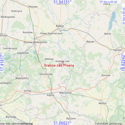
Grabów nad Prosną GPS coordinates[2]
51° 30' 21.456" North, 18° 7' 9.444" East
| Map corner | latitude | longitude |
|---|---|---|
| Upper-left | 51.94151°, | 17.41617° |
| Center: | 51.50596°, | 18.11929° |
| Lower-right: | 51.06621°, | 18.82242° |
| Map W x H: | 97.3×97.3 km | = 60.5×60.5mi |
| max Lat: | 54.83135° ⇑43.6% North |
| Grabów nad Prosną: | 51.50596° |
| min Lat: | ⇓56.4% South 49.21328° |
| min Long | Grabów nad Pro | max Long |
| 14.20249° | 18.11929° | 24.03723° |
| W 26.1%⇐ | ⇒73.9% E |
Elevation
Elevation of Grabów nad Prosną is 130 m = 427 ft, and this is 61.4 m = 201 ft below average elevation for this country.
| Max E: |
974 m = 3196 ft | 66.1% |
| Avg. | 191.4 m = 628 ft | |
| Grabów nad Prosną | 130 m = 427 ft | |
Min E: |
-3 m = -10 ft | 33.9% |
See also: Poland elevation on elevation.city.
Geographical zone
Grabów nad Prosną is located in North temperate zone (between Tropic of Cancer and the Arctic Circle). Distance of this North polar circle is 1674.2 km =1040.3 mi to North.| Distance of | km | miles | from Grabów nad Prosną |
|---|---|---|---|
| North Pole | 4280.1 | 2659.5 | to North |
| Arctic Circle | 1674.2 | 1040.3 | to North |
| Tropic Cancer | 3121 | 1939.3 | to South |
| Equator | 5726.9 | 3558.5 | to South |


Nearby cities:
15 places around Grabów nad Prosną: (largest is in red/bold)
• Brzeziny
13.7 km =8.5 mi,  43°
43°
• Brąszewice
22.9 km =14.2 mi,  91°
91°
• Czajków
14.5 km =9 mi,  96°
96°
• Doruchów
10.3 km =6.4 mi,  196°
196°
• Galewice
20.3 km =12.6 mi,  151°
151°
• Godziesze Wielkie
15.8 km =9.8 mi,  13°
13°
• Klonowa
22.8 km =14.2 mi,  114°
114°
• Kraszewice
7.1 km =4.4 mi,  78°
78°
• Mikstat
10.5 km =6.5 mi,  286°
286°
• Osiek
16.3 km =10.1 mi,  160°
160°
• Ostrzeszów
15.6 km =9.7 mi,  235°
235°
• Przygodzice
22.5 km =14 mi,  295°
295°
• Psary
18.4 km =11.4 mi,  336°
336°
• Sieroszewice
17.5 km =10.9 mi,  324°
324°
• Wieruszów
23.6 km =14.7 mi,  173°
173°
Sources, notices
• [Note1] Compared only with cities in Poland existing in our database
• [Src1] Map data: © OpenStreetMap contributors (CC-BY-SA)
• [Src2] Other city data from geonames.org with taken over terms of usage.
• [Src3] Geographical zone / Annual Mean Temperature by Robert A. Rohde @ Wikipedia
