Brzeziny geodata
Brzeziny (Greater Poland) is a populated place; located in Poland in Europe/Warsaw (GMT+2) time zone. With population of 860 people, there are 2749 cities with bigger population in this country. Compared to other cities in Poland, 57.8% of cities are located further ↓South; 71.9% of cities are located further →East and 65% of cities have higher elevation than Brzeziny. Note1


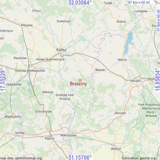
Brzeziny GPS coordinates[2]
51° 35' 45.42" North, 18° 15' 19.476" East
| Map corner | latitude | longitude |
|---|---|---|
| Upper-left | 52.03064°, | 17.55229° |
| Center: | 51.59595°, | 18.25541° |
| Lower-right: | 51.15706°, | 18.95854° |
| Map W x H: | 97.1×97.1 km | = 60.3×60.3mi |
| max Lat: | 54.83135° ⇑42.2% North |
| Brzeziny: | 51.59595° |
| min Lat: | ⇓57.8% South 49.21328° |
| min Long | Brzeziny | max Long |
| 14.20249° | 18.25541° | 24.03723° |
| W 28.1%⇐ | ⇒71.9% E |
Elevation
Elevation of Brzeziny is 133 m = 436 ft, and this is 58.4 m = 192 ft below average elevation for this country.
| Max E: |
974 m = 3196 ft | 65% |
| Avg. | 191.4 m = 628 ft | |
| Brzeziny | 133 m = 436 ft | |
Min E: |
-3 m = -10 ft | 35% |
See also: Poland elevation on elevation.city.
Geographical zone
Brzeziny is located in North temperate zone (between Tropic of Cancer and the Arctic Circle). Distance of this North polar circle is 1664.2 km =1034.1 mi to North.| Distance of | km | miles | from Brzeziny |
|---|---|---|---|
| North Pole | 4270.1 | 2653.3 | to North |
| Arctic Circle | 1664.2 | 1034.1 | to North |
| Tropic Cancer | 3131 | 1945.5 | to South |
| Equator | 5736.9 | 3564.7 | to South |


Nearby cities:
15 places around Brzeziny: (largest is in red/bold)
• Borysławice
13.4 km =8.3 mi,  61°
61°
• Brąszewice
17.2 km =10.7 mi,  128°
128°
• Błaszki
13.8 km =8.6 mi, 63°
• Czajków
12.6 km =7.8 mi,  156°
156°
• Godziesze Wielkie
7.9 km =4.9 mi,  313°
313°
• Grabów nad Prosną
13.7 km =8.5 mi,  223°
223°
• Kalisz
21.6 km =13.4 mi,  328°
328°
• Klonowa
22.6 km =14 mi,  150°
150°
• Kraszewice
8.9 km =5.5 mi,  195°
195°
• Mikstat
20.7 km =12.9 mi,  250°
250°
• Nowe Skalmierzyce
22.1 km =13.7 mi, 305°
• Opatówek
16.2 km =10.1 mi,  350°
350°
• Psary
18.1 km =11.2 mi,  292°
292°
• Sieroszewice
20 km =12.4 mi,  282°
282°
• Szczytniki
11.6 km =7.2 mi,  26°
26°
Sources, notices
• [Note1] Compared only with cities in Poland existing in our database
• [Src1] Map data: © OpenStreetMap contributors (CC-BY-SA)
• [Src2] Other city data from geonames.org with taken over terms of usage.
• [Src3] Geographical zone / Annual Mean Temperature by Robert A. Rohde @ Wikipedia
