Buk geodata
Buk (Greater Poland) is a seat of a third-order administrative division; located in Poland in Europe/Warsaw (GMT+2) time zone. With population of 6,102 people, there are 594 cities with bigger population in this country. Compared to other cities in Poland, 73.7% of cities are located further ↓South; 89.4% of cities are located further →East and 86.8% of cities have higher elevation than Buk. Note1


Buk GPS coordinates[2]
52° 21' 19.152" North, 16° 31' 10.488" East
| Map corner | latitude | longitude |
|---|---|---|
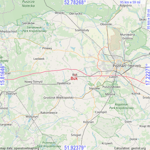
| Upper-left | 52.78268°, | 15.81646° |
| Center: | 52.35532°, | 16.51958° |
| Lower-right: | 51.92379°, | 17.22271° |
| Map W x H: | 95.5×95.5 km | = 59.3×59.3mi |
| max Lat: | 54.83135° ⇑26.3% North |
| Buk: | 52.35532° |
| min Lat: | ⇓73.7% South 49.21328° |
| min Long | Buk | max Long |
| 14.20249° | 16.51958° | 24.03723° |
| W 10.6%⇐ | ⇒89.4% E |
Elevation
Elevation of Buk is 85 m = 279 ft, and this is 106.4 m = 349 ft below average elevation for this country.
| Max E: |
974 m = 3196 ft | 86.8% |
| Avg. | 191.4 m = 628 ft | |
| Buk | 85 m = 279 ft | |
Min E: |
-3 m = -10 ft | 13.2% |
See also: Poland elevation on elevation.city.
Geographical zone
Buk is located in North temperate zone (between Tropic of Cancer and the Arctic Circle). Distance of this North polar circle is 1579.8 km =981.6 mi to North.| Distance of | km | miles | from Buk |
|---|---|---|---|
| North Pole | 4185.7 | 2600.9 | to North |
| Arctic Circle | 1579.8 | 981.6 | to North |
| Tropic Cancer | 3215.4 | 1998 | to South |
| Equator | 5821.4 | 3617.2 | to South |


Nearby cities:
15 places around Buk: (largest is in red/bold)
• Baranowo
20.2 km =12.6 mi,  63°
63°
• Brody
17.8 km =11.1 mi,  301°
301°
• Dopiewo
10.6 km =6.6 mi,  88°
88°
• Duszniki
12.8 km =8 mi,  322°
322°
• Granowo
14.8 km =9.2 mi,  177°
177°
• Grodzisk Wielkopolski
17.7 km =11 mi,  216°
216°
• Kaźmierz
18.1 km =11.2 mi,  13°
13°
• Komorniki
19.9 km =12.4 mi,  95°
95°
• Kuślin
13.9 km =8.6 mi,  273°
273°
• Opalenica
8.9 km =5.5 mi,  234°
234°
• Pakosław
20.5 km =12.7 mi, 295°
• Plewiska
19.8 km =12.3 mi, 86°
• Stęszew
14.7 km =9.1 mi,  122°
122°
• Tarnowo Podgórne
15.7 km =9.8 mi,  38°
38°
• Zakrzewo
14.6 km =9.1 mi,  73°
73°
Sources, notices
• [Note1] Compared only with cities in Poland existing in our database
• [Src1] Map data: © OpenStreetMap contributors (CC-BY-SA)
• [Src2] Other city data from geonames.org with taken over terms of usage.
• [Src3] Geographical zone / Annual Mean Temperature by Robert A. Rohde @ Wikipedia
