Duszniki geodata
Duszniki (Greater Poland) is a seat of a third-order administrative division; located in Poland in Europe/Warsaw (GMT+2) time zone. With population of 2,100 people, there are 1411 cities with bigger population in this country. Compared to other cities in Poland, 75.6% of cities are located further ↓South; 90.1% of cities are located further →East and 84.6% of cities have higher elevation than Duszniki. Note1


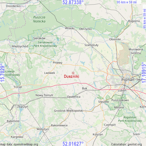
Duszniki GPS coordinates[2]
52° 26' 48.876" North, 16° 24' 21.672" East
| Map corner | latitude | longitude |
|---|---|---|
| Upper-left | 52.87338°, | 15.7029° |
| Center: | 52.44691°, | 16.40602° |
| Lower-right: | 52.01627°, | 17.10915° |
| Map W x H: | 95.3×95.3 km | = 59.2×59.2mi |
| max Lat: | 54.83135° ⇑24.4% North |
| Duszniki: | 52.44691° |
| min Lat: | ⇓75.6% South 49.21328° |
| min Long | Duszniki | max Long |
| 14.20249° | 16.40602° | 24.03723° |
| W 9.9%⇐ | ⇒90.1% E |
Elevation
Elevation of Duszniki is 90 m = 295 ft, and this is 101.4 m = 333 ft below average elevation for this country.
| Max E: |
974 m = 3196 ft | 84.6% |
| Avg. | 191.4 m = 628 ft | |
| Duszniki | 90 m = 295 ft | |
Min E: |
-3 m = -10 ft | 15.4% |
See also: Poland elevation on elevation.city.
Geographical zone
Duszniki is located in North temperate zone (between Tropic of Cancer and the Arctic Circle). Distance of this North polar circle is 1569.6 km =975.3 mi to North.| Distance of | km | miles | from Duszniki |
|---|---|---|---|
| North Pole | 4175.5 | 2594.5 | to North |
| Arctic Circle | 1569.6 | 975.3 | to North |
| Tropic Cancer | 3225.6 | 2004.3 | to South |
| Equator | 5831.5 | 3623.5 | to South |


Nearby cities:
15 places around Duszniki: (largest is in red/bold)
• Brody
7.6 km =4.7 mi,  263°
263°
• Buk
12.8 km =8 mi,  142°
142°
• Dopiewo
20.8 km =12.9 mi,  118°
118°
• Kaźmierz
14.1 km =8.8 mi,  58°
58°
• Kuślin
11.1 km =6.9 mi,  213°
213°
• Lipnica
14.7 km =9.1 mi,  19°
19°
• Lwówek
15.2 km =9.4 mi,  270°
270°
• Opalenica
15.4 km =9.6 mi,  178°
178°
• Ostroróg
20.2 km =12.6 mi,  8°
8°
• Pakosław
10.9 km =6.8 mi, 262°
• Pamiątkowo
22.1 km =13.7 mi, 57°
• Pniewy
12.3 km =7.6 mi,  304°
304°
• Szamotuły
21.7 km =13.5 mi,  32°
32°
• Tarnowo Podgórne
17.6 km =10.9 mi,  82°
82°
• Zakrzewo
22.4 km =13.9 mi,  105°
105°
Sources, notices
• [Note1] Compared only with cities in Poland existing in our database
• [Src1] Map data: © OpenStreetMap contributors (CC-BY-SA)
• [Src2] Other city data from geonames.org with taken over terms of usage.
• [Src3] Geographical zone / Annual Mean Temperature by Robert A. Rohde @ Wikipedia
