Grodzisk Wielkopolski geodata
Grodzisk Wielkopolski (Greater Poland) is a seat of a third-order administrative division; located in Poland in Europe/Warsaw (GMT+2) time zone. With population of 13,826 people, there are 357 cities with bigger population in this country. Compared to other cities in Poland, 70.8% of cities are located further ↓South; 90.4% of cities are located further →East and 86.3% of cities have higher elevation than Grodzisk Wielkopolski. Note1
Administrative division(s):
- Level 1: Greater Poland
- Level 2: Powiat grodziski
- Level 3: Grodzisk Wielkopolski
Current local time in Grodzisk Wielkopolski:
04:09 AM, SaturdayDifference from your time zone: hours


Grodzisk Wielkopolski GPS coordinates[2]
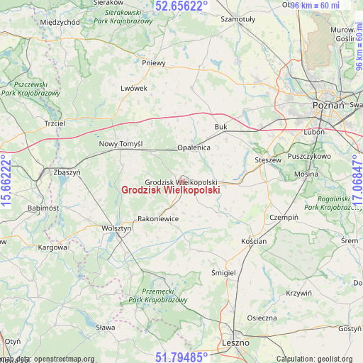
52° 13' 39.432" North, 16° 21' 55.224" East
| Map corner | latitude | longitude |
|---|---|---|
| Upper-left | 52.65622°, | 15.66222° |
| Center: | 52.22762°, | 16.36534° |
| Lower-right: | 51.79485°, | 17.06847° |
| Map W x H: | 95.8×95.8 km | = 59.5×59.5mi |
| max Lat: | 54.83135° ⇑29.2% North |
| Grodzisk Wielkopolski: | 52.22762° |
| min Lat: | ⇓70.8% South 49.21328° |
| min Long | Grodzisk Wielko | max Long |
| 14.20249° | 16.36534° | 24.03723° |
| W 9.6%⇐ | ⇒90.4% E |
Elevation
Elevation of Grodzisk Wielkopolski is 86 m = 282 ft, and this is 105.4 m = 346 ft below average elevation for this country.
| Max E: |
974 m = 3196 ft | 86.3% |
| Avg. | 191.4 m = 628 ft | |
| Grodzisk Wielkopolski | 86 m = 282 ft | |
Min E: |
-3 m = -10 ft | 13.7% |
See also: Poland elevation on elevation.city.
Geographical zone
Grodzisk Wielkopolski is located in North temperate zone (between Tropic of Cancer and the Arctic Circle). Distance of this North polar circle is 1594 km =990.5 mi to North.| Distance of | km | miles | from Grodzisk Wielkopolski |
|---|---|---|---|
| North Pole | 4199.9 | 2609.7 | to North |
| Arctic Circle | 1594 | 990.5 | to North |
| Tropic Cancer | 3201.2 | 1989.1 | to South |
| Equator | 5807.2 | 3608.4 | to South |


Nearby cities:
15 places around Grodzisk Wielkopolski: (largest is in red/bold)
• Brody
23.9 km =14.9 mi,  348°
348°
• Buk
17.7 km =11 mi,  36°
36°
• Duszniki
24.5 km =15.2 mi,  6°
6°
• Granowo
11.1 km =6.9 mi,  92°
92°
• Jabłonna
11 km =6.8 mi,  257°
257°
• Kamieniec
9.5 km =5.9 mi,  136°
136°
• Kościan
24.8 km =15.4 mi,  128°
128°
• Kuślin
15.5 km =9.6 mi, 347°
• Nowy Tomyśl
19.1 km =11.9 mi,  302°
302°
• Opalenica
9.6 km =6 mi,  19°
19°
• Pakosław
24.4 km =15.2 mi,  340°
340°
• Rakoniewice
11.7 km =7.3 mi,  212°
212°
• Stęszew
23.7 km =14.7 mi,  74°
74°
• Wielichowo
12.5 km =7.8 mi,  184°
184°
• Wolsztyn
21 km =13 mi,  233°
233°
Sources, notices
• [Note1] Compared only with cities in Poland existing in our database
• [Src1] Map data: © OpenStreetMap contributors (CC-BY-SA)
• [Src2] Other city data from geonames.org with taken over terms of usage.
• [Src3] Geographical zone / Annual Mean Temperature by Robert A. Rohde @ Wikipedia
