Brody geodata
Brody (Greater Poland) is a populated place; located in Poland in Europe/Warsaw (GMT+2) time zone. With population of 724 people, there are 3020 cities with bigger population in this country. Compared to other cities in Poland, 75.4% of cities are located further ↓South; 90.8% of cities are located further →East and 80.6% of cities have higher elevation than Brody. Note1


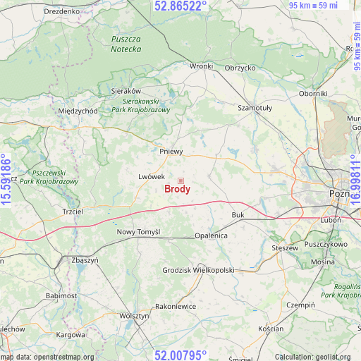
Brody GPS coordinates[2]
52° 26' 19.212" North, 16° 17' 41.928" East
| Map corner | latitude | longitude |
|---|---|---|
| Upper-left | 52.86522°, | 15.59186° |
| Center: | 52.43867°, | 16.29498° |
| Lower-right: | 52.00795°, | 16.99811° |
| Map W x H: | 95.3×95.3 km | = 59.2×59.2mi |
| max Lat: | 54.83135° ⇑24.6% North |
| Brody: | 52.43867° |
| min Lat: | ⇓75.4% South 49.21328° |
| min Long | Brody | max Long |
| 14.20249° | 16.29498° | 24.03723° |
| W 9.2%⇐ | ⇒90.8% E |
Elevation
Elevation of Brody is 98 m = 322 ft, and this is 93.4 m = 306 ft below average elevation for this country.
| Max E: |
974 m = 3196 ft | 80.6% |
| Avg. | 191.4 m = 628 ft | |
| Brody | 98 m = 322 ft | |
Min E: |
-3 m = -10 ft | 19.4% |
See also: Poland elevation on elevation.city.
Geographical zone
Brody is located in North temperate zone (between Tropic of Cancer and the Arctic Circle). Distance of this North polar circle is 1570.5 km =975.9 mi to North.| Distance of | km | miles | from Brody |
|---|---|---|---|
| North Pole | 4176.4 | 2595.1 | to North |
| Arctic Circle | 1570.5 | 975.9 | to North |
| Tropic Cancer | 3224.7 | 2003.7 | to South |
| Equator | 5830.6 | 3623 | to South |


Nearby cities:
15 places around Brody: (largest is in red/bold)
• Buk
17.8 km =11.1 mi,  121°
121°
• Chrzypsko Wielkie
21.5 km =13.4 mi,  347°
347°
• Duszniki
7.6 km =4.7 mi,  83°
83°
• Grodzisk Wielkopolski
23.9 km =14.9 mi,  168°
168°
• Kaźmierz
21.3 km =13.2 mi,  67°
67°
• Kuślin
8.4 km =5.2 mi, 170°
• Kwilcz
19.2 km =11.9 mi,  312°
312°
• Lipnica
19.3 km =12 mi,  40°
40°
• Lutom
23.3 km =14.5 mi,  333°
333°
• Lwówek
7.8 km =4.8 mi,  277°
277°
• Nowy Tomyśl
17.4 km =10.8 mi,  220°
220°
• Opalenica
16.5 km =10.3 mi,  151°
151°
• Ostroróg
23.4 km =14.5 mi,  26°
26°
• Pakosław
3.3 km =2.1 mi,  262°
262°
• Pniewy
8.3 km =5.2 mi,  341°
341°
Sources, notices
• [Note1] Compared only with cities in Poland existing in our database
• [Src1] Map data: © OpenStreetMap contributors (CC-BY-SA)
• [Src2] Other city data from geonames.org with taken over terms of usage.
• [Src3] Geographical zone / Annual Mean Temperature by Robert A. Rohde @ Wikipedia
