Wiązów geodata
Wiązów (Lower Silesia) is a populated place; located in Poland in Europe/Warsaw (GMT+2) time zone. With population of 2,340 people, there are 1308 cities with bigger population in this country. Compared to other cities in Poland, 59.8% of cities are located further ↑North; 82.1% of cities are located further →East and 57.6% of cities have higher elevation than Wiązów. Note1


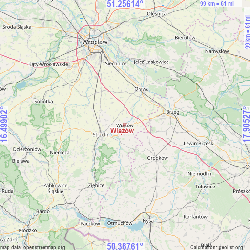
Wiązów GPS coordinates[2]
50° 48' 50.364" North, 17° 12' 7.704" East
| Map corner | latitude | longitude |
|---|---|---|
| Upper-left | 51.25614°, | 16.49902° |
| Center: | 50.81399°, | 17.20214° |
| Lower-right: | 50.36761°, | 17.90527° |
| Map W x H: | 98.8×98.8 km | = 61.4×61.4mi |
| max Lat: | 54.83135° ⇑59.8% North |
| Wiązów: | 50.81399° |
| min Lat: | ⇓40.2% South 49.21328° |
| min Long | Wiązów | max Long |
| 14.20249° | 17.20214° | 24.03723° |
| W 17.9%⇐ | ⇒82.1% E |
Elevation
Elevation of Wiązów is 152 m = 499 ft, and this is 39.4 m = 129 ft below average elevation for this country.
| Max E: |
974 m = 3196 ft | 57.6% |
| Avg. | 191.4 m = 628 ft | |
| Wiązów | 152 m = 499 ft | |
Min E: |
-3 m = -10 ft | 42.4% |
See also: Poland elevation on elevation.city.
Geographical zone
Wiązów is located in North temperate zone (between Tropic of Cancer and the Arctic Circle). Distance of this North polar circle is 1751.2 km =1088.1 mi to North.| Distance of | km | miles | from Wiązów |
|---|---|---|---|
| North Pole | 4357.1 | 2707.4 | to North |
| Arctic Circle | 1751.2 | 1088.1 | to North |
| Tropic Cancer | 3044.1 | 1891.5 | to South |
| Equator | 5650 | 3510.7 | to South |


Nearby cities:
15 places around Wiązów: (largest is in red/bold)
• Borów
16.7 km =10.4 mi,  297°
297°
• Brzeg
19.3 km =12 mi,  74°
74°
• Domaniów
10.2 km =6.3 mi,  330°
330°
• Grodków
18.2 km =11.3 mi,  135°
135°
• Kondratowice
19.3 km =12 mi,  256°
256°
• Krzyżowice
18.4 km =11.4 mi,  92°
92°
• Olszanka
19.6 km =12.2 mi,  96°
96°
• Osiek
10.3 km =6.4 mi,  37°
37°
• Oława
16.1 km =10 mi,  23°
23°
• Pogorzela
20.7 km =12.9 mi, 98°
• Przeworno
14.4 km =8.9 mi,  190°
190°
• Skarbimierz Osiedle
15.6 km =9.7 mi,  76°
76°
• Strzelin
10.3 km =6.4 mi,  249°
249°
• Wierzbno
13.7 km =8.5 mi,  353°
353°
• Węgry
17.1 km =10.6 mi,  318°
318°
Sources, notices
• [Note1] Compared only with cities in Poland existing in our database
• [Src1] Map data: © OpenStreetMap contributors (CC-BY-SA)
• [Src2] Other city data from geonames.org with taken over terms of usage.
• [Src3] Geographical zone / Annual Mean Temperature by Robert A. Rohde @ Wikipedia
