Miedzichowo geodata
Miedzichowo (Greater Poland) is a seat of a third-order administrative division; located in Poland in Europe/Warsaw (GMT+2) time zone. With population of 471 people, there are 3555 cities with bigger population in this country. Compared to other cities in Poland, 74.3% of cities are located further ↓South; 92.7% of cities are located further →East and 91.6% of cities have higher elevation than Miedzichowo. Note1
Administrative division(s):
- Level 1: Greater Poland
- Level 2: Powiat nowotomyski
- Level 3: Miedzichowo


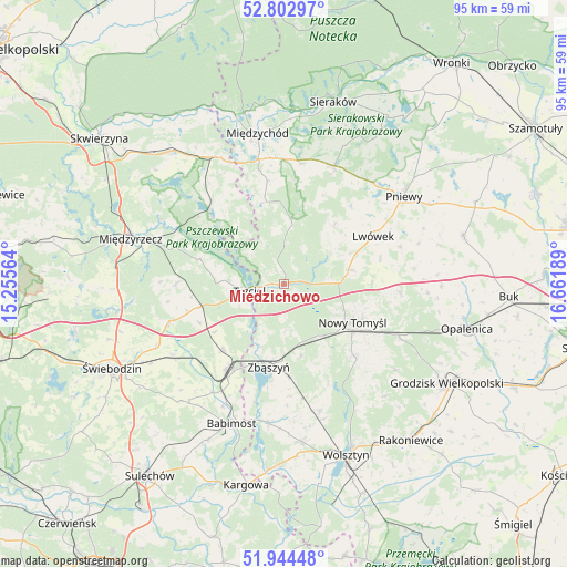
Miedzichowo GPS coordinates[2]
52° 22' 32.916" North, 15° 57' 31.536" East
| Map corner | latitude | longitude |
|---|---|---|
| Upper-left | 52.80297°, | 15.25564° |
| Center: | 52.37581°, | 15.95876° |
| Lower-right: | 51.94448°, | 16.66189° |
| Map W x H: | 95.5×95.5 km | = 59.3×59.3mi |
| max Lat: | 54.83135° ⇑25.7% North |
| Miedzichowo: | 52.37581° |
| min Lat: | ⇓74.3% South 49.21328° |
| min Long | Miedzichowo | max Long |
| 14.20249° | 15.95876° | 24.03723° |
| W 7.3%⇐ | ⇒92.7% E |
Elevation
Elevation of Miedzichowo is 67 m = 220 ft, and this is 124.4 m = 408 ft below average elevation for this country.
| Max E: |
974 m = 3196 ft | 91.6% |
| Avg. | 191.4 m = 628 ft | |
| Miedzichowo | 67 m = 220 ft | |
Min E: |
-3 m = -10 ft | 8.4% |
See also: Poland elevation on elevation.city.
Geographical zone
Miedzichowo is located in North temperate zone (between Tropic of Cancer and the Arctic Circle). Distance of this North polar circle is 1577.5 km =980.2 mi to North.| Distance of | km | miles | from Miedzichowo |
|---|---|---|---|
| North Pole | 4183.4 | 2599.4 | to North |
| Arctic Circle | 1577.5 | 980.2 | to North |
| Tropic Cancer | 3217.7 | 1999.4 | to South |
| Equator | 5823.6 | 3618.6 | to South |


Nearby cities:
15 places around Miedzichowo: (largest is in red/bold)
• Babimost
25.1 km =15.6 mi,  200°
200°
• Brody
23.9 km =14.9 mi,  72°
72°
• Brójce
20.4 km =12.7 mi,  251°
251°
• Kuślin
24.2 km =15 mi,  93°
93°
• Kwilcz
21.7 km =13.5 mi,  23°
23°
• Lwówek
17.1 km =10.6 mi,  61°
61°
• Nowy Tomyśl
13.1 km =8.1 mi,  118°
118°
• Pakosław
20.6 km =12.8 mi, 71°
• Pniewy
25.1 km =15.6 mi,  53°
53°
• Pszczew
16.5 km =10.3 mi,  313°
313°
• Szczaniec
22.3 km =13.9 mi,  237°
237°
• Trzciel
5.9 km =3.7 mi,  258°
258°
• Zbąszynek
17.6 km =10.9 mi,  213°
213°
• Zbąszyń
14.1 km =8.8 mi,  189°
189°
• Łowyń
14.3 km =8.9 mi,  346°
346°
Sources, notices
• [Note1] Compared only with cities in Poland existing in our database
• [Src1] Map data: © OpenStreetMap contributors (CC-BY-SA)
• [Src2] Other city data from geonames.org with taken over terms of usage.
• [Src3] Geographical zone / Annual Mean Temperature by Robert A. Rohde @ Wikipedia
