Maszewo geodata
Maszewo (Lubusz) is a seat of a third-order administrative division; located in Poland in Europe/Warsaw (GMT+2) time zone. With population of 460 people, there are 3556 cities with bigger population in this country. Compared to other cities in Poland, 66.9% of cities are located further ↓South; 98.5% of cities are located further →East and 92.7% of cities have higher elevation than Maszewo. Note1


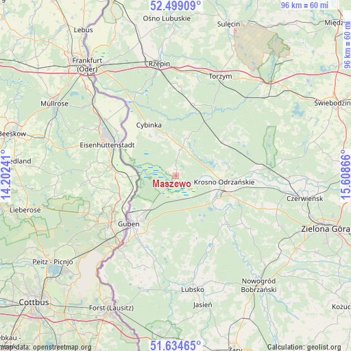
Maszewo GPS coordinates[2]
52° 4' 8.256" North, 14° 54' 19.908" East
| Map corner | latitude | longitude |
|---|---|---|
| Upper-left | 52.49909°, | 14.20241° |
| Center: | 52.06896°, | 14.90553° |
| Lower-right: | 51.63465°, | 15.60866° |
| Map W x H: | 96.1×96.1 km | = 59.7×59.7mi |
| max Lat: | 54.83135° ⇑33.1% North |
| Maszewo: | 52.06896° |
| min Lat: | ⇓66.9% South 49.21328° |
| min Long | Maszewo | max Long |
| 14.20249° | 14.90553° | 24.03723° |
| W 1.5%⇐ | ⇒98.5% E |
Elevation
Elevation of Maszewo is 61 m = 200 ft, and this is 130.4 m = 428 ft below average elevation for this country.
| Max E: |
974 m = 3196 ft | 92.7% |
| Avg. | 191.4 m = 628 ft | |
| Maszewo | 61 m = 200 ft | |
Min E: |
-3 m = -10 ft | 7.3% |
See also: Poland elevation on elevation.city.
Geographical zone
Maszewo is located in North temperate zone (between Tropic of Cancer and the Arctic Circle). Distance of this North polar circle is 1611.6 km =1001.4 mi to North.| Distance of | km | miles | from Maszewo |
|---|---|---|---|
| North Pole | 4217.5 | 2620.6 | to North |
| Arctic Circle | 1611.6 | 1001.4 | to North |
| Tropic Cancer | 3183.6 | 1978.2 | to South |
| Equator | 5789.5 | 3597.4 | to South |


Nearby cities:
15 places around Maszewo: (largest is in red/bold)
• Bobrowice
18.4 km =11.4 mi,  136°
136°
• Boczów
28.3 km =17.6 mi,  5°
5°
• Brody
32.3 km =20.1 mi,  196°
196°
• Bytnica
20.2 km =12.6 mi,  63°
63°
• Cybinka
15.8 km =9.8 mi,  331°
331°
• Czerwieńsk
35.9 km =22.3 mi,  99°
99°
• Dychów
14 km =8.7 mi,  130°
130°
• Dąbie
18.1 km =11.2 mi,  111°
111°
• Gubin
18 km =11.2 mi,  222°
222°
• Krosno Odrzańskie
13.3 km =8.3 mi, 96°
• Lubsko
31.9 km =19.8 mi,  171°
171°
• Międzylesie
33.7 km =20.9 mi,  75°
75°
• Osiecznica
9.9 km =6.2 mi, 84°
• Rzepin
31.2 km =19.4 mi,  350°
350°
• Torzym
29.7 km =18.5 mi,  23°
23°
Sources, notices
• [Note1] Compared only with cities in Poland existing in our database
• [Src1] Map data: © OpenStreetMap contributors (CC-BY-SA)
• [Src2] Other city data from geonames.org with taken over terms of usage.
• [Src3] Geographical zone / Annual Mean Temperature by Robert A. Rohde @ Wikipedia
