Iłowo -Osada geodata
Iłowo -Osada (Warmia-Masuria) is a populated place; located in Poland in Europe/Warsaw (GMT+2) time zone. With population of 2,800 people, there are 1120 cities with bigger population in this country. Compared to other cities in Poland, 85.9% of cities are located further ↓South; 62.4% of cities are located further ←West and 55.3% of cities have higher elevation than Iłowo -Osada. Note1
Administrative division(s):
- Level 1: Warmia-Masuria
- Level 2: Powiat działdowski
- Level 3: Iłowo-Osada


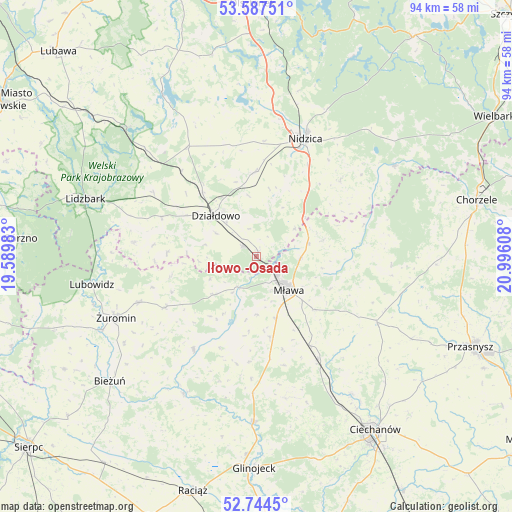
Iłowo -Osada GPS coordinates[2]
53° 10' 5.088" North, 20° 17' 34.62" East
| Map corner | latitude | longitude |
|---|---|---|
| Upper-left | 53.58751°, | 19.58983° |
| Center: | 53.16808°, | 20.29295° |
| Lower-right: | 52.7445°, | 20.99608° |
| Map W x H: | 93.7×93.7 km | = 58.2×58.2mi |
| max Lat: | 54.83135° ⇑14.1% North |
| Iłowo -Osada: | 53.16808° |
| min Lat: | ⇓85.9% South 49.21328° |
| min Long | Iłowo -Osada | max Long |
| 14.20249° | 20.29295° | 24.03723° |
| W 62.4%⇐ | ⇒37.6% E |
Elevation
Elevation of Iłowo -Osada is 158 m = 518 ft, and this is 33.4 m = 110 ft below average elevation for this country.
| Max E: |
974 m = 3196 ft | 55.3% |
| Avg. | 191.4 m = 628 ft | |
| Iłowo -Osada | 158 m = 518 ft | |
Min E: |
-3 m = -10 ft | 44.7% |
See also: Poland elevation on elevation.city.
Geographical zone
Iłowo -Osada is located in North temperate zone (between Tropic of Cancer and the Arctic Circle). Distance of this North polar circle is 1489.4 km =925.5 mi to North.| Distance of | km | miles | from Iłowo -Osada |
|---|---|---|---|
| North Pole | 4095.3 | 2544.7 | to North |
| Arctic Circle | 1489.4 | 925.5 | to North |
| Tropic Cancer | 3305.8 | 2054.1 | to South |
| Equator | 5911.7 | 3673.4 | to South |


Nearby cities:
15 places around Iłowo -Osada: (largest is in red/bold)
• Działdowo
11.4 km =7.1 mi,  314°
314°
• Dzierzgowo
24.7 km =15.3 mi,  93°
93°
• Grudusk
25.3 km =15.7 mi,  118°
118°
• Kozłowo
15.4 km =9.6 mi,  359°
359°
• Kuczbork-Osada
18.7 km =11.6 mi,  240°
240°
• Kuczbork-Wieś
19.2 km =11.9 mi, 240°
• Lipowiec Kościelny
10.5 km =6.5 mi,  227°
227°
• Mława
8.6 km =5.3 mi,  135°
135°
• Nidzica
23.2 km =14.4 mi,  22°
22°
• Płośnica
22 km =13.7 mi,  301°
301°
• Stupsk
18.8 km =11.7 mi,  149°
149°
• Szreńsk
20.8 km =12.9 mi,  213°
213°
• Szydłowo
14.3 km =8.9 mi,  132°
132°
• Wieczfnia Kościelna
12.6 km =7.8 mi,  76°
76°
• Wiśniewo
12.1 km =7.5 mi,  162°
162°
Sources, notices
• [Note1] Compared only with cities in Poland existing in our database
• [Src1] Map data: © OpenStreetMap contributors (CC-BY-SA)
• [Src2] Other city data from geonames.org with taken over terms of usage.
• [Src3] Geographical zone / Annual Mean Temperature by Robert A. Rohde @ Wikipedia
