Grudusk geodata
Grudusk (Mazovia) is a seat of a third-order administrative division; located in Poland in Europe/Warsaw (GMT+2) time zone. With population of 1,500 people, there are 1837 cities with bigger population in this country. Compared to other cities in Poland, 84.4% of cities are located further ↓South; 66.6% of cities are located further ←West and 62.4% of cities have higher elevation than Grudusk. Note1


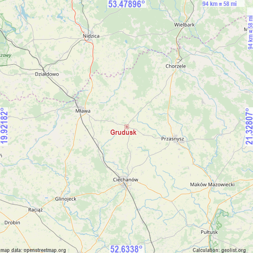
Grudusk GPS coordinates[2]
53° 3' 30.42" North, 20° 37' 29.784" East
| Map corner | latitude | longitude |
|---|---|---|
| Upper-left | 53.47896°, | 19.92182° |
| Center: | 53.05845°, | 20.62494° |
| Lower-right: | 52.6338°, | 21.32807° |
| Map W x H: | 94×94 km | = 58.4×58.4mi |
| max Lat: | 54.83135° ⇑15.6% North |
| Grudusk: | 53.05845° |
| min Lat: | ⇓84.4% South 49.21328° |
| min Long | Grudusk | max Long |
| 14.20249° | 20.62494° | 24.03723° |
| W 66.6%⇐ | ⇒33.4% E |
Elevation
Elevation of Grudusk is 141 m = 463 ft, and this is 50.4 m = 165 ft below average elevation for this country.
| Max E: |
974 m = 3196 ft | 62.4% |
| Avg. | 191.4 m = 628 ft | |
| Grudusk | 141 m = 463 ft | |
Min E: |
-3 m = -10 ft | 37.6% |
See also: Poland elevation on elevation.city.
Geographical zone
Grudusk is located in North temperate zone (between Tropic of Cancer and the Arctic Circle). Distance of this North polar circle is 1501.6 km =933.1 mi to North.| Distance of | km | miles | from Grudusk |
|---|---|---|---|
| North Pole | 4107.5 | 2552.3 | to North |
| Arctic Circle | 1501.6 | 933.1 | to North |
| Tropic Cancer | 3293.6 | 2046.5 | to South |
| Equator | 5899.5 | 3665.8 | to South |


Nearby cities:
15 places around Grudusk: (largest is in red/bold)
• Ciechanów
19.7 km =12.2 mi,  180°
180°
• Czernice Borowe
7 km =4.3 mi,  114°
114°
• Dzierzgowo
10.8 km =6.7 mi,  13°
13°
• Iłowo -Osada
25.3 km =15.7 mi,  298°
298°
• Janowo
28.8 km =17.9 mi, 6°
• Krasne
27.4 km =17 mi,  123°
123°
• Krzynowłoga Mała
15.4 km =9.6 mi,  44°
44°
• Mława
17.2 km =10.7 mi,  290°
290°
• Opinogóra Górna
18.1 km =11.2 mi,  159°
159°
• Przasnysz
17.6 km =10.9 mi,  104°
104°
• Regimin
13.8 km =8.6 mi,  200°
200°
• Stupsk
13.2 km =8.2 mi,  252°
252°
• Szydłowo
11.9 km =7.4 mi,  281°
281°
• Wieczfnia Kościelna
18.2 km =11.3 mi,  326°
326°
• Wiśniewo
18.5 km =11.5 mi,  272°
272°
Sources, notices
• [Note1] Compared only with cities in Poland existing in our database
• [Src1] Map data: © OpenStreetMap contributors (CC-BY-SA)
• [Src2] Other city data from geonames.org with taken over terms of usage.
• [Src3] Geographical zone / Annual Mean Temperature by Robert A. Rohde @ Wikipedia
