Wiśniewo geodata
Wiśniewo (Mazovia) is a seat of a third-order administrative division; located in Poland in Europe/Warsaw (GMT+2) time zone. With population of 473 people, there are 3554 cities with bigger population in this country. Compared to other cities in Poland, 84.4% of cities are located further ↓South; 63.2% of cities are located further ←West and 63% of cities have higher elevation than Wiśniewo. Note1


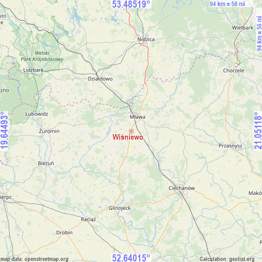
Wiśniewo GPS coordinates[2]
53° 3' 53.064" North, 20° 20' 52.98" East
| Map corner | latitude | longitude |
|---|---|---|
| Upper-left | 53.48519°, | 19.64493° |
| Center: | 53.06474°, | 20.34805° |
| Lower-right: | 52.64015°, | 21.05118° |
| Map W x H: | 94×94 km | = 58.4×58.4mi |
| max Lat: | 54.83135° ⇑15.6% North |
| Wiśniewo: | 53.06474° |
| min Lat: | ⇓84.4% South 49.21328° |
| min Long | Wiśniewo | max Long |
| 14.20249° | 20.34805° | 24.03723° |
| W 63.2%⇐ | ⇒36.8% E |
Elevation
Elevation of Wiśniewo is 139 m = 456 ft, and this is 52.4 m = 172 ft below average elevation for this country.
| Max E: |
974 m = 3196 ft | 63% |
| Avg. | 191.4 m = 628 ft | |
| Wiśniewo | 139 m = 456 ft | |
Min E: |
-3 m = -10 ft | 37% |
See also: Poland elevation on elevation.city.
Geographical zone
Wiśniewo is located in North temperate zone (between Tropic of Cancer and the Arctic Circle). Distance of this North polar circle is 1500.9 km =932.6 mi to North.| Distance of | km | miles | from Wiśniewo |
|---|---|---|---|
| North Pole | 4106.8 | 2551.8 | to North |
| Arctic Circle | 1500.9 | 932.6 | to North |
| Tropic Cancer | 3294.3 | 2047 | to South |
| Equator | 5900.2 | 3666.2 | to South |


Nearby cities:
15 places around Wiśniewo: (largest is in red/bold)
• Działdowo
22.8 km =14.2 mi,  328°
328°
• Dzierzgowo
23.2 km =14.4 mi,  65°
65°
• Grudusk
18.5 km =11.5 mi,  92°
92°
• Iłowo -Osada
12.1 km =7.5 mi,  342°
342°
• Kuczbork-Osada
20.2 km =12.6 mi,  276°
276°
• Kuczbork-Wieś
20.5 km =12.7 mi, 275°
• Lipowiec Kościelny
12.3 km =7.6 mi,  291°
291°
• Mława
5.9 km =3.7 mi,  24°
24°
• Radzanów
21.9 km =13.6 mi,  231°
231°
• Regimin
19.4 km =12.1 mi,  134°
134°
• Strzegowo
19.4 km =12.1 mi,  192°
192°
• Stupsk
7.6 km =4.7 mi, 128°
• Szreńsk
16.3 km =10.1 mi,  249°
249°
• Szydłowo
7.1 km =4.4 mi,  75°
75°
• Wieczfnia Kościelna
16.9 km =10.5 mi,  30°
30°
Sources, notices
• [Note1] Compared only with cities in Poland existing in our database
• [Src1] Map data: © OpenStreetMap contributors (CC-BY-SA)
• [Src2] Other city data from geonames.org with taken over terms of usage.
• [Src3] Geographical zone / Annual Mean Temperature by Robert A. Rohde @ Wikipedia
