Stupsk geodata
Stupsk (Mazovia) is a seat of a third-order administrative division; located in Poland in Europe/Warsaw (GMT+2) time zone. With population of 783 people, there are 2893 cities with bigger population in this country. Compared to other cities in Poland, 83.9% of cities are located further ↓South; 64.2% of cities are located further ←West and 65% of cities have higher elevation than Stupsk. Note1


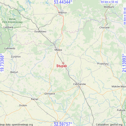
Stupsk GPS coordinates[2]
53° 1' 21.288" North, 20° 26' 12.48" East
| Map corner | latitude | longitude |
|---|---|---|
| Upper-left | 53.44344°, | 19.73368° |
| Center: | 53.02258°, | 20.4368° |
| Lower-right: | 52.59757°, | 21.13993° |
| Map W x H: | 94.1×94 km | = 58.5×58.4mi |
| max Lat: | 54.83135° ⇑16.1% North |
| Stupsk: | 53.02258° |
| min Lat: | ⇓83.9% South 49.21328° |
| min Long | Stupsk | max Long |
| 14.20249° | 20.4368° | 24.03723° |
| W 64.2%⇐ | ⇒35.8% E |
Elevation
Elevation of Stupsk is 133 m = 436 ft, and this is 58.4 m = 192 ft below average elevation for this country.
| Max E: |
974 m = 3196 ft | 65% |
| Avg. | 191.4 m = 628 ft | |
| Stupsk | 133 m = 436 ft | |
Min E: |
-3 m = -10 ft | 35% |
See also: Poland elevation on elevation.city.
Geographical zone
Stupsk is located in North temperate zone (between Tropic of Cancer and the Arctic Circle). Distance of this North polar circle is 1505.6 km =935.5 mi to North.| Distance of | km | miles | from Stupsk |
|---|---|---|---|
| North Pole | 4111.5 | 2554.8 | to North |
| Arctic Circle | 1505.6 | 935.5 | to North |
| Tropic Cancer | 3289.6 | 2044.1 | to South |
| Equator | 5895.6 | 3663.4 | to South |


Nearby cities:
15 places around Stupsk: (largest is in red/bold)
• Ciechanów
19.9 km =12.4 mi,  141°
141°
• Czernice Borowe
18.9 km =11.7 mi,  86°
86°
• Dzierzgowo
20.9 km =13 mi,  46°
46°
• Glinojeck
24.5 km =15.2 mi,  203°
203°
• Grudusk
13.2 km =8.2 mi,  72°
72°
• Iłowo -Osada
18.8 km =11.7 mi,  329°
329°
• Lipowiec Kościelny
19.6 km =12.2 mi,  297°
297°
• Mława
10.6 km =6.6 mi,  340°
340°
• Opinogóra Górna
22.9 km =14.2 mi,  124°
124°
• Regimin
11.9 km =7.4 mi, 139°
• Strzegowo
17.5 km =10.9 mi,  215°
215°
• Szreńsk
21.2 km =13.2 mi,  267°
267°
• Szydłowo
6.5 km =4 mi,  8°
8°
• Wieczfnia Kościelna
19.4 km =12.1 mi, 7°
• Wiśniewo
7.6 km =4.7 mi,  308°
308°
Sources, notices
• [Note1] Compared only with cities in Poland existing in our database
• [Src1] Map data: © OpenStreetMap contributors (CC-BY-SA)
• [Src2] Other city data from geonames.org with taken over terms of usage.
• [Src3] Geographical zone / Annual Mean Temperature by Robert A. Rohde @ Wikipedia
