Brochów geodata
Brochów (Mazovia) is a seat of a third-order administrative division; located in Poland in Europe/Warsaw (GMT+2) time zone. With population of 400 people, there are 3589 cities with bigger population in this country. Compared to other cities in Poland, 73% of cities are located further ↓South; 62% of cities are located further ←West and 91.3% of cities have higher elevation than Brochów. Note1


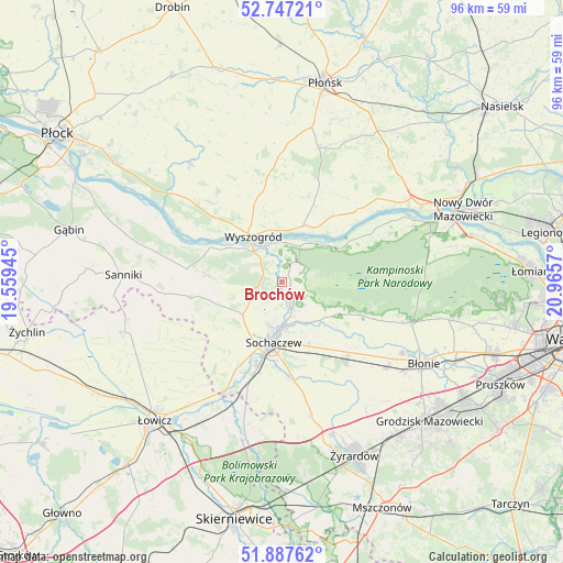
Brochów GPS coordinates[2]
52° 19' 10.2" North, 20° 15' 45.252" East
| Map corner | latitude | longitude |
|---|---|---|
| Upper-left | 52.74721°, | 19.55945° |
| Center: | 52.3195°, | 20.26257° |
| Lower-right: | 51.88762°, | 20.9657° |
| Map W x H: | 95.6×95.6 km | = 59.4×59.4mi |
| max Lat: | 54.83135° ⇑27% North |
| Brochów: | 52.3195° |
| min Lat: | ⇓73% South 49.21328° |
| min Long | Brochów | max Long |
| 14.20249° | 20.26257° | 24.03723° |
| W 62%⇐ | ⇒38% E |
Elevation
Elevation of Brochów is 69 m = 226 ft, and this is 122.4 m = 402 ft below average elevation for this country.
| Max E: |
974 m = 3196 ft | 91.3% |
| Avg. | 191.4 m = 628 ft | |
| Brochów | 69 m = 226 ft | |
Min E: |
-3 m = -10 ft | 8.7% |
See also: Poland elevation on elevation.city.
Geographical zone
Brochów is located in North temperate zone (between Tropic of Cancer and the Arctic Circle). Distance of this North polar circle is 1583.8 km =984.1 mi to North.| Distance of | km | miles | from Brochów |
|---|---|---|---|
| North Pole | 4189.7 | 2603.4 | to North |
| Arctic Circle | 1583.8 | 984.1 | to North |
| Tropic Cancer | 3211.5 | 1995.5 | to South |
| Equator | 5817.4 | 3614.8 | to South |


Nearby cities:
15 places around Brochów: (largest is in red/bold)
• Boża Wola
23.2 km =14.4 mi,  129°
129°
• Czerwińsk Nad Wisłą
9.3 km =5.8 mi,  20°
20°
• Czerwonka-Parcel
11.5 km =7.1 mi,  179°
179°
• Iłów
16.1 km =10 mi,  277°
277°
• Kampinos
14.8 km =9.2 mi,  112°
112°
• Kocierzew Południowy
20.1 km =12.5 mi,  235°
235°
• Kozłów Biskupi
15 km =9.3 mi,  198°
198°
• Mała Wieś
18.8 km =11.7 mi,  324°
324°
• Młodzieszyn
4.8 km =3 mi, 242°
• Paprotnia
16.8 km =10.4 mi,  139°
139°
• Rybno
13.8 km =8.6 mi,  231°
231°
• Sochaczew
10.1 km =6.3 mi,  189°
189°
• Słubice
22.7 km =14.1 mi, 284°
• Teresin
17 km =10.6 mi, 141°
• Wyszogród
9.2 km =5.7 mi,  328°
328°
Sources, notices
• [Note1] Compared only with cities in Poland existing in our database
• [Src1] Map data: © OpenStreetMap contributors (CC-BY-SA)
• [Src2] Other city data from geonames.org with taken over terms of usage.
• [Src3] Geographical zone / Annual Mean Temperature by Robert A. Rohde @ Wikipedia
