Naruszewo geodata
Naruszewo (Mazovia) is a seat of a third-order administrative division; located in Poland in Europe/Warsaw (GMT+2) time zone. With population of 222 people, there are 3640 cities with bigger population in this country. Compared to other cities in Poland, 76.9% of cities are located further ↓South; 63.3% of cities are located further ←West and 67.1% of cities have higher elevation than Naruszewo. Note1


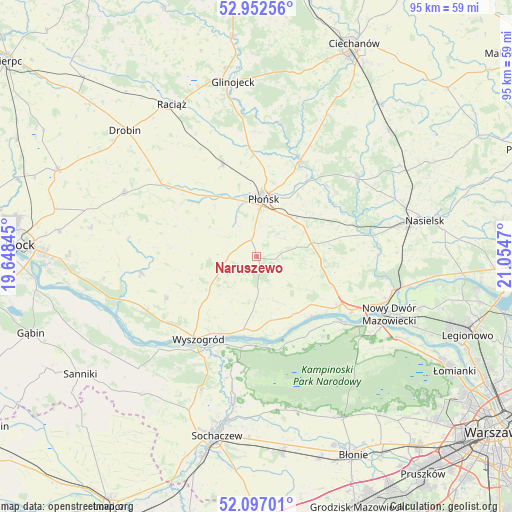
Naruszewo GPS coordinates[2]
52° 31' 36.732" North, 20° 21' 5.652" East
| Map corner | latitude | longitude |
|---|---|---|
| Upper-left | 52.95256°, | 19.64845° |
| Center: | 52.52687°, | 20.35157° |
| Lower-right: | 52.09701°, | 21.0547° |
| Map W x H: | 95.1×95.1 km | = 59.1×59.1mi |
| max Lat: | 54.83135° ⇑23.1% North |
| Naruszewo: | 52.52687° |
| min Lat: | ⇓76.9% South 49.21328° |
| min Long | Naruszewo | max Long |
| 14.20249° | 20.35157° | 24.03723° |
| W 63.3%⇐ | ⇒36.7% E |
Elevation
Elevation of Naruszewo is 128 m = 420 ft, and this is 63.4 m = 208 ft below average elevation for this country.
| Max E: |
974 m = 3196 ft | 67.1% |
| Avg. | 191.4 m = 628 ft | |
| Naruszewo | 128 m = 420 ft | |
Min E: |
-3 m = -10 ft | 32.9% |
See also: Poland elevation on elevation.city.
Geographical zone
Naruszewo is located in North temperate zone (between Tropic of Cancer and the Arctic Circle). Distance of this North polar circle is 1560.7 km =969.8 mi to North.| Distance of | km | miles | from Naruszewo |
|---|---|---|---|
| North Pole | 4166.6 | 2589 | to North |
| Arctic Circle | 1560.7 | 969.8 | to North |
| Tropic Cancer | 3234.5 | 2009.8 | to South |
| Equator | 5840.4 | 3629.1 | to South |


Nearby cities:
15 places around Naruszewo: (largest is in red/bold)
• Baboszewo
18.3 km =11.4 mi,  339°
339°
• Bodzanów
22 km =13.7 mi,  262°
262°
• Brochów
23.8 km =14.8 mi,  194°
194°
• Bulkowo
15.8 km =9.8 mi,  275°
275°
• Czerwińsk Nad Wisłą
14.6 km =9.1 mi, 191°
• Dzierzążnia
13.8 km =8.6 mi,  324°
324°
• Joniec
17.6 km =10.9 mi,  61°
61°
• Mała Wieś
18.5 km =11.5 mi,  245°
245°
• Nowe Miasto
23.6 km =14.7 mi,  52°
52°
• Pomiechówek
26.3 km =16.3 mi,  103°
103°
• Płońsk
10.9 km =6.8 mi,  8°
8°
• Sochocin
19.6 km =12.2 mi,  24°
24°
• Wyszogród
18.7 km =11.6 mi,  215°
215°
• Zakroczym
20.5 km =12.7 mi,  120°
120°
• Załuski
12.1 km =7.5 mi, 98°
Sources, notices
• [Note1] Compared only with cities in Poland existing in our database
• [Src1] Map data: © OpenStreetMap contributors (CC-BY-SA)
• [Src2] Other city data from geonames.org with taken over terms of usage.
• [Src3] Geographical zone / Annual Mean Temperature by Robert A. Rohde @ Wikipedia
