Bulkowo geodata
Bulkowo (Mazovia) is a seat of a third-order administrative division; located in Poland in Europe/Warsaw (GMT+2) time zone. With population of 266 people, there are 3634 cities with bigger population in this country. Compared to other cities in Poland, 77% of cities are located further ↓South; 60.4% of cities are located further ←West and 68.2% of cities have higher elevation than Bulkowo. Note1


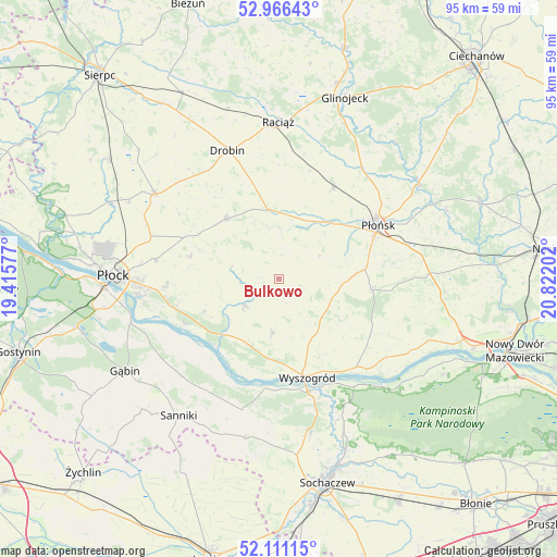
Bulkowo GPS coordinates[2]
52° 32' 27.132" North, 20° 7' 8.004" East
| Map corner | latitude | longitude |
|---|---|---|
| Upper-left | 52.96643°, | 19.41577° |
| Center: | 52.54087°, | 20.11889° |
| Lower-right: | 52.11115°, | 20.82202° |
| Map W x H: | 95.1×95.1 km | = 59.1×59.1mi |
| max Lat: | 54.83135° ⇑23% North |
| Bulkowo: | 52.54087° |
| min Lat: | ⇓77% South 49.21328° |
| min Long | Bulkowo | max Long |
| 14.20249° | 20.11889° | 24.03723° |
| W 60.4%⇐ | ⇒39.6% E |
Elevation
Elevation of Bulkowo is 125 m = 410 ft, and this is 66.4 m = 218 ft below average elevation for this country.
| Max E: |
974 m = 3196 ft | 68.2% |
| Avg. | 191.4 m = 628 ft | |
| Bulkowo | 125 m = 410 ft | |
Min E: |
-3 m = -10 ft | 31.8% |
See also: Poland elevation on elevation.city.
Geographical zone
Bulkowo is located in North temperate zone (between Tropic of Cancer and the Arctic Circle). Distance of this North polar circle is 1559.2 km =968.8 mi to North.| Distance of | km | miles | from Bulkowo |
|---|---|---|---|
| North Pole | 4165.1 | 2588.1 | to North |
| Arctic Circle | 1559.2 | 968.8 | to North |
| Tropic Cancer | 3236.1 | 2010.8 | to South |
| Equator | 5842 | 3630 | to South |


Nearby cities:
15 places around Bulkowo: (largest is in red/bold)
• Baboszewo
18.1 km =11.2 mi,  30°
30°
• Bodzanów
7.6 km =4.7 mi,  233°
233°
• Czerwińsk Nad Wisłą
20.5 km =12.7 mi,  140°
140°
• Drobin
23.6 km =14.7 mi,  338°
338°
• Dzierzążnia
12.4 km =7.7 mi,  38°
38°
• Iłów
23.2 km =14.4 mi,  195°
195°
• Mała Wieś
9.3 km =5.8 mi,  186°
186°
• Naruszewo
15.8 km =9.8 mi,  95°
95°
• Płońsk
19.6 km =12.2 mi,  62°
62°
• Radzanowo
15.8 km =9.8 mi,  283°
283°
• Staroźreby
13.6 km =8.5 mi,  318°
318°
• Słubice
22.6 km =14 mi,  212°
212°
• Słupno
19.4 km =12.1 mi,  258°
258°
• Wyszogród
17.5 km =10.9 mi,  163°
163°
• Łaziska
24.5 km =15.2 mi,  221°
221°
Sources, notices
• [Note1] Compared only with cities in Poland existing in our database
• [Src1] Map data: © OpenStreetMap contributors (CC-BY-SA)
• [Src2] Other city data from geonames.org with taken over terms of usage.
• [Src3] Geographical zone / Annual Mean Temperature by Robert A. Rohde @ Wikipedia
